IMAGES TAKEN NEAR TO
Greengate Lane, MANCHESTER, M25 3HW
Introduction
This page details the photographs taken nearby to Greengate Lane, M25 3HW by members of the Geograph project.
The Geograph project started in 2005 with the aim of publishing, organising and preserving representative images for every square kilometre of Great Britain, Ireland and the Isle of Man.

There are currently over 7.5m images from over14,400 individuals and you can help contribute to the project by visiting https://www.geograph.org.uk
Image Map
Images are licensed for reuse under creativecommons.org/licenses/by-sa/2.0
Notes
- Clicking on the map will re-center to the selected point.
- The higher the marker number, the further away the image location is from the centre of the postcode.
Image Listing (125 Images Found)
Images are licensed for reuse under creativecommons.org/licenses/by-sa/2.0
Image
Details
Distance
2
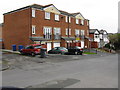
Modern Housing on Church Drive, Prestwich
Image: © Peter Whatley
Taken: 28 Feb 2009
0.05 miles
3
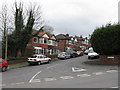
Semi-Detached Houses on Church Drive, Prestwich
Image: © Peter Whatley
Taken: 28 Feb 2009
0.07 miles
4
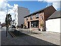
Warwick Street, Prestwich
The road is cut off from Bury New Road. On the right is "All The Shapes" which opened in 2015 as a Bar, Café and Gathering Place. http://www.alltheshapes.co.uk/about/ During the coronavirus pandemic lockdown they have only been able to offer a takeaway service. With restrictions due to be eased they are in the process of preparing a space with tables in the street where customers will be able to get together outside.
Image: © Gerald England
Taken: 9 Apr 2021
0.09 miles
5
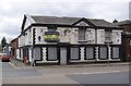
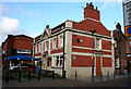
The Grapes Inn
Sadly neglected former public house on Bury New Road.
Image: © David Dixon
Taken: 27 Mar 2010
0.10 miles
7
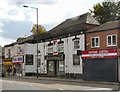
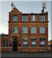
The Bank Practice
The former Midland Bank on Bury New Road is now a Dental and Medical treatment centre.
Image: © Gerald England
Taken: 13 Sep 2011
0.10 miles
8
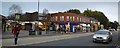
Prestwich panorama
A silver BMW heads northwards towards the M60 Junction 17 as the man in the red fleece sets off to cross the A56 Bury New Road to Warwick Street. Further south along the road is the curved façade of the 1930s brick building that houses the Cancer Research shop, contrasting with the angular 1960s Longfield Shopping Centre.
Image: © Bobby Clegg
Taken: 4 Nov 2015
0.10 miles
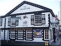
10
Prestwich: The 'White Horse'
Prestich is a convenient place to make a change from Metrolink to the excellent X43 Witch Way bus to Nelson, which runs along Bury New Road just a short walk from the tram station. If you should require a drink, the White Horse would be a good choice, with Holt's very palatable real ale.
Image: © Dr Neil Clifton
Taken: 4 Nov 2014
0.11 miles