IMAGES TAKEN NEAR TO
Oaks Close, MANCHESTER, M25 3ER
Introduction
This page details the photographs taken nearby to Oaks Close, M25 3ER by members of the Geograph project.
The Geograph project started in 2005 with the aim of publishing, organising and preserving representative images for every square kilometre of Great Britain, Ireland and the Isle of Man.

There are currently over 7.5m images from over14,400 individuals and you can help contribute to the project by visiting https://www.geograph.org.uk
Image Map
Images are licensed for reuse under creativecommons.org/licenses/by-sa/2.0
Notes
- Clicking on the map will re-center to the selected point.
- The higher the marker number, the further away the image location is from the centre of the postcode.
Image Listing (36 Images Found)
Images are licensed for reuse under creativecommons.org/licenses/by-sa/2.0
Image
Details
Distance
3
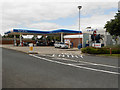
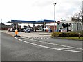
Tesco Fuel Forecourt, Prestwich
The petrol station at Tesco's Prestwich store.
Image: © David Dixon
Taken: 28 Jul 2012
0.12 miles
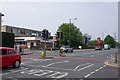
4
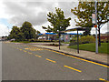
Bus Stop, Pinfold Drive
The bus stop on Pinfold Drive, between Prestwich Hospital and the Tesco Supermarket.
Image: © David Dixon
Taken: 28 Jul 2012
0.12 miles
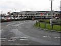
6
View of Bury New Road (Post Office and KFC) from M&S
Image: © Ivor Josephson
Taken: 26 Apr 2020
0.13 miles
7
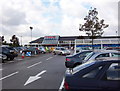
Superstore
A daytime view of Tesco, Prestwich.
Image: © Keith Williamson
Taken: 19 Sep 2006
0.13 miles
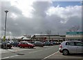

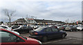
10
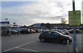
The car park of Tesco, Prestwich
They allow 3 hours free parking here. Many stores only allow 2 hours.
Image: © Bill Boaden
Taken: 9 Sep 2010
0.14 miles