IMAGES TAKEN NEAR TO
Newtown Street, MANCHESTER, M25 1HU
Introduction
This page details the photographs taken nearby to Newtown Street, M25 1HU by members of the Geograph project.
The Geograph project started in 2005 with the aim of publishing, organising and preserving representative images for every square kilometre of Great Britain, Ireland and the Isle of Man.

There are currently over 7.5m images from over14,400 individuals and you can help contribute to the project by visiting https://www.geograph.org.uk
Image Map
Images are licensed for reuse under creativecommons.org/licenses/by-sa/2.0
Notes
- Clicking on the map will re-center to the selected point.
- The higher the marker number, the further away the image location is from the centre of the postcode.
Image Listing (121 Images Found)
Images are licensed for reuse under creativecommons.org/licenses/by-sa/2.0
Image
Details
Distance
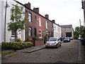
1
Heaton Park Congregational Church, Prestwich
Another one bites the dust
Image: © Alexander P Kapp
Taken: 16 Jul 2007
0.02 miles
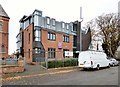
2
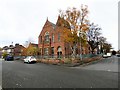
Heaton Park Congregational Church
The Grade II listed building https://historicengland.org.uk/listing/the-list/list-entry/1356841 on Newton Street was designed by Alfred Waterhouse and opened in 1881. In 2006 the congregation, unable to afford the upkeep of the building, sold it to developers for conversion into apartments. The deal involved the developer building a new church on land behind the old church. The new church is now called The Studio and hosts a number of community services.
Image: © Gerald England
Taken: 10 Nov 2018
0.02 miles
3
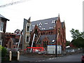
Heaton Park Congregational Church, Prestwich
Somebody must have shares in Velux windows
Image: © Alexander P Kapp
Taken: 16 Jul 2007
0.02 miles
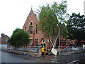
4
The Studio
When the congregation at the Grade II listed building https://historicengland.org.uk/listing/the-list/list-entry/1356841 on Newton Street was designed by Alfred Waterhouse and opened in 1881 Image were no longer able to afford the upkeep of the building, it was sold it to developers for conversion into apartments. The deal involved the developer building a new church on land behind the old church, with apartments above it. The new church was called The Studio and hosted a number of community services. It seems that worship no longer takes place here and the ground floor of the new church is now for sale.
Image: © Gerald England
Taken: 10 Nov 2018
0.03 miles
5
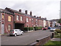
Heaton Street (eastern end) - 12-5-2011
Heaton Street near its junction with Bailey Street
Image: © Duncan Watts
Taken: 12 May 2011
0.04 miles
6
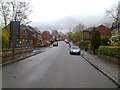
Newtown Street, Prestwich
Looking towards Bury Old Road
Image: © Duncan Watts
Taken: 22 Apr 2012
0.04 miles
7
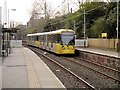
Tram Arriving at Heaton Park
Metrolink Bombardier M5000 tram number 3008 arrives at Heaton Park Station as part of a double unit operating the service between Bury and Altrincham.
The Heaton Park Railway Station first opened in 1879 on the Lancashire & Yorkshire Railway's new line between Manchester and Bury. It has operated as a Metrolink stop/station since the line was converted when the Metrolink system started operating in 1992. The former booking office building was removed in 2001 and the footbridge and stairway roofs were removed and the stairs rebuilt in 2011/2.
Image: © David Dixon
Taken: 8 Mar 2014
0.05 miles
8
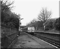
Looking West at Heaton Park station
A Down train for Bury has just left. The overbridge carries a minor urban road which is Russell Street to the left, and Newtown Street to the right.
Image: © Dr Neil Clifton
Taken: 21 Apr 1990
0.05 miles
9
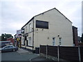
The Commercial, Prestwich
On Bury Old Road.
Image: © JThomas
Taken: 10 Sep 2018
0.06 miles