IMAGES TAKEN NEAR TO
Randlesham Street, MANCHESTER, M25 1GY
Introduction
This page details the photographs taken nearby to Randlesham Street, M25 1GY by members of the Geograph project.
The Geograph project started in 2005 with the aim of publishing, organising and preserving representative images for every square kilometre of Great Britain, Ireland and the Isle of Man.

There are currently over 7.5m images from over14,400 individuals and you can help contribute to the project by visiting https://www.geograph.org.uk
Image Map
Images are licensed for reuse under creativecommons.org/licenses/by-sa/2.0
Notes
- Clicking on the map will re-center to the selected point.
- The higher the marker number, the further away the image location is from the centre of the postcode.
Image Listing (70 Images Found)
Images are licensed for reuse under creativecommons.org/licenses/by-sa/2.0
Image
Details
Distance
1
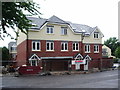
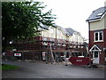
Eco houses, Prestwich
These houses being built by Seddon, have the latest spec on insulation, roof panels and wind turbines, they also have a cooling system because they are so well insulated they need to be cooled down occasionally.
Image: © Alexander P Kapp
Taken: 16 Jul 2007
0.04 miles
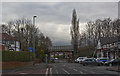
3
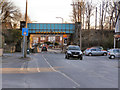
Heywood Road Bridge
Bridge where the Metrolink trams cross Heywood Road, approximately half way between the Prestwich and Heaton Park stations.
Image: © David Dixon
Taken: 7 Mar 2010
0.10 miles
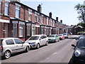
4
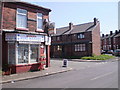
Brandram Road, Prestwich, Manchester, M25
Munir's mini market at the junction with Cromwell Road and Heaton Street still provides a local shop service for the surrounding streets
Image: © Duncan Watts
Taken: 28 Apr 2011
0.10 miles
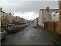
6
Brandram Road, Prestwich, Manchester M25
This street links St Austell's Drive with Heaton Street and Cromwell Road.
Image: © Duncan Watts
Taken: 28 Apr 2011
0.11 miles
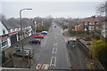
8
Hampden Road, Prestwich
Looking eastwards
Image: © Duncan Watts
Taken: 22 Apr 2012
0.14 miles
9
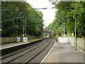
Heaton Park Station
The original platforms for the railway seem to extend to the road bridge. The Metrolink uses only the platform to the picket fence.
Image: © Kevin Waterhouse
Taken: 7 Sep 2023
0.14 miles
10
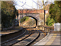
Newtown Street Bridge
The bridge carrying Newtown Street over the Metrolink, just to the west of Heaton Park Station.
Image: © David Dixon
Taken: 11 Mar 2010
0.15 miles