IMAGES TAKEN NEAR TO
The Drive, MANCHESTER, M25 1BJ
Introduction
This page details the photographs taken nearby to The Drive, M25 1BJ by members of the Geograph project.
The Geograph project started in 2005 with the aim of publishing, organising and preserving representative images for every square kilometre of Great Britain, Ireland and the Isle of Man.

There are currently over 7.5m images from over14,400 individuals and you can help contribute to the project by visiting https://www.geograph.org.uk
Image Map
Images are licensed for reuse under creativecommons.org/licenses/by-sa/2.0
Notes
- Clicking on the map will re-center to the selected point.
- The higher the marker number, the further away the image location is from the centre of the postcode.
Image Listing (91 Images Found)
Images are licensed for reuse under creativecommons.org/licenses/by-sa/2.0
Image
Details
Distance
1
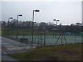
Prestwich Cricket Club - Pavilion
Looking across the tennis courts at Prestwich Sports Club's "The Heys" ground towards the cricket pavilion. The cricket club runs two teams in the Lancashire County League and a third XI in the North Manchester Cricket League.
Image: © BatAndBall
Taken: 8 Mar 2013
0.10 miles
2
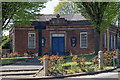
PADOS House, Prestwich
Prestwich Amateur Dramatic and Opera Society studio at the junction of St Mary's Road and Rectory Lane.
The local war memorial is visible on the approach to the building.
Image: © Ivor Josephson
Taken: 21 Apr 2020
0.11 miles
3
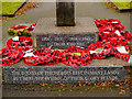
Prestwich War Memorial Dedication
Dedication on Image] reads:
1914 - 1918 1939 - 1945
TO THOSE WHO FELL
THE BODIES OF THE HEROES REST IN MANY LANDS
BUT HERE THE SYMBOL OF THEIR GLORY STANDS
Image: © David Dixon
Taken: 27 Dec 2012
0.12 miles
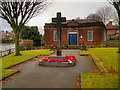
4
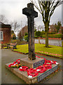
Rectory Lane War Memorial
This memorial, in the form of a large wooden cross, stands in a small memorial garden at the meeting of St Mary's Road and Rectory Lane in Prestwich.
The dedication (Image]) reads:
1914 - 1918 1939 - 1945
TO THOSE WHO FELL
THE BODIES OF THE HEROES REST IN MANY LANDS
BUT HERE THE SYMBOL OF THEIR GLORY STANDS
Image: © David Dixon
Taken: 27 Dec 2012
0.12 miles
5
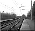
Prestwich station
Looking south from Prestwich, a Metrolink car for Bury is just approaching
Image: © Dr Neil Clifton
Taken: 6 Apr 1992
0.13 miles
6
War Memorial, St Mary's Road/Rectory Lane
This memorial, in the form of a large wooden cross, stands in a small memorial garden at the meeting of St Mary's Road and Rectory Lane in Prestwich.
The dedication (Image]) reads:
1914 - 1918 1939 - 1945
TO THOSE WHO FELL
THE BODIES OF THE HEROES REST IN MANY LANDS
BUT HERE THE SYMBOL OF THEIR GLORY STANDS
Image: © David Dixon
Taken: 27 Dec 2012
0.13 miles
7
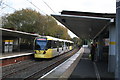
Prestwich Metrolink station
Looking south, a double unit is just about to depart, probably for Altrincham. Traffic on the Bury line has grown so much that most services here are allocated a double unit.
Image: © Dr Neil Clifton
Taken: 4 Nov 2014
0.15 miles
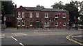
8
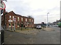
Red Lion, Prestwich
A Joseph Holts pub on Bury New Road (A56).
Image
Image: © Gerald England
Taken: 11 Jan 2018
0.15 miles
10
Red Lion, Prestwich
Red Lion is a public house located on Bury New Road, in central Prestwich, Greater Manchester, England.
Image: © Steven Haslington
Taken: 27 Aug 2012
0.15 miles