IMAGES TAKEN NEAR TO
Branksome Avenue, MANCHESTER, M25 1AG
Introduction
This page details the photographs taken nearby to Branksome Avenue, M25 1AG by members of the Geograph project.
The Geograph project started in 2005 with the aim of publishing, organising and preserving representative images for every square kilometre of Great Britain, Ireland and the Isle of Man.

There are currently over 7.5m images from over14,400 individuals and you can help contribute to the project by visiting https://www.geograph.org.uk
Image Map
Images are licensed for reuse under creativecommons.org/licenses/by-sa/2.0
Notes
- Clicking on the map will re-center to the selected point.
- The higher the marker number, the further away the image location is from the centre of the postcode.
Image Listing (90 Images Found)
Images are licensed for reuse under creativecommons.org/licenses/by-sa/2.0
Image
Details
Distance
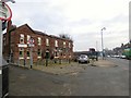
1
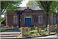
PADOS House, Prestwich
Prestwich Amateur Dramatic and Opera Society studio at the junction of St Mary's Road and Rectory Lane.
The local war memorial is visible on the approach to the building.
Image: © Ivor Josephson
Taken: 21 Apr 2020
0.07 miles
2
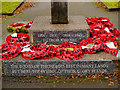
Prestwich War Memorial Dedication
Dedication on Image] reads:
1914 - 1918 1939 - 1945
TO THOSE WHO FELL
THE BODIES OF THE HEROES REST IN MANY LANDS
BUT HERE THE SYMBOL OF THEIR GLORY STANDS
Image: © David Dixon
Taken: 27 Dec 2012
0.10 miles
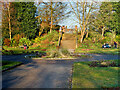
3
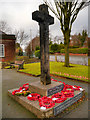
Rectory Lane War Memorial
This memorial, in the form of a large wooden cross, stands in a small memorial garden at the meeting of St Mary's Road and Rectory Lane in Prestwich.
The dedication (Image]) reads:
1914 - 1918 1939 - 1945
TO THOSE WHO FELL
THE BODIES OF THE HEROES REST IN MANY LANDS
BUT HERE THE SYMBOL OF THEIR GLORY STANDS
Image: © David Dixon
Taken: 27 Dec 2012
0.10 miles
4
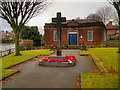
War Memorial, St Mary's Road/Rectory Lane
This memorial, in the form of a large wooden cross, stands in a small memorial garden at the meeting of St Mary's Road and Rectory Lane in Prestwich.
The dedication (Image]) reads:
1914 - 1918 1939 - 1945
TO THOSE WHO FELL
THE BODIES OF THE HEROES REST IN MANY LANDS
BUT HERE THE SYMBOL OF THEIR GLORY STANDS
Image: © David Dixon
Taken: 27 Dec 2012
0.10 miles
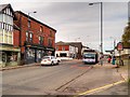
5
Red Lion, Prestwich
A Joseph Holts pub on Bury New Road (A56).
Image
Image: © Gerald England
Taken: 11 Jan 2018
0.10 miles
6
St Mary's Flower Park, Prestwich
St Mary's Park at Prestwich is divided by Bury New Road into the flower park (on the western side of the road) and the playing field (on the eastern side).
St Mary's Park and the Flower Park were officially opened by the 17th Earl of Derby on 3 October 1931. The park was then known as St Mary's Playing Fields and the Flower Park known as St Mary's Park. St Mary's Playing Fields was originally glebe land (land given to a clergyman) belonging to St Mary's Church, which was bought by Prestwich Urban Council for £100 in 1927.
The flower park still contains a number of its original horticultural features, including a layout of formal beds. This area of the park is a quiet place to sit and relax and is bordered by Prestwich Clough.
https://web.archive.org/web/20210313145358/https://www.bury.gov.uk/index.aspx?articleid=11191 Bury MBC archived March 2021
Image: © David Dixon
Taken: 6 Mar 2021
0.11 miles
8
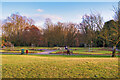
The Flower Park, Prestwich
St Mary's Park at Prestwich is divided by Bury New Road into the flower park (on the western side of the road) and the playing field (on the eastern side).
St Mary's Park and the Flower Park were officially opened by the 17th Earl of Derby on 3 October 1931. The park was then known as St Mary's Playing Fields and the Flower Park known as St Mary's Park. St Mary's Playing Fields was originally glebe land (land given to a clergyman) belonging to St Mary's Church, which was bought by Prestwich Urban Council for £100 in 1927.
The flower park still contains a number of its original horticultural features, including a layout of formal beds. This area of the park is a quiet place to sit and relax and is bordered by Prestwich Clough.
https://web.archive.org/web/20210313145358/https://www.bury.gov.uk/index.aspx?articleid=11191 Bury MBC archived March 2021
Image: © David Dixon
Taken: 6 Mar 2021
0.11 miles
9
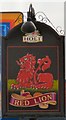
Sign of the Red Lion
Sign for the Red Lion Image
Image: © Gerald England
Taken: 11 Jan 2018
0.11 miles
10
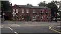
Red Lion, Prestwich
Red Lion is a public house located on Bury New Road, in central Prestwich, Greater Manchester, England.
Image: © Steven Haslington
Taken: 27 Aug 2012
0.11 miles