1
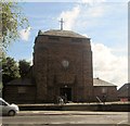
Broughton, synagogue
Holy Law Synagogue on Bury New Road. http://www.manchester2002-uk.com/worship/worship7.html
Image: © Mike Faherty
Taken: 19 Oct 2009
0.13 miles
2
St Gabriel's Church, Sedgley Park, Prestwich
Image: © Alexander P Kapp
Taken: 19 Sep 2005
0.15 miles
3
Manchester from the air
Broughton Park is in the foreground, with the distinctive meanders on the River Irwell visible on the right, with the city centre in the centre of the photo.
Viewed from a Manchester bound flight from Prague.
Image: © Thomas Nugent
Taken: 18 Apr 2014
0.17 miles
4
St Gabriel's Church, Prestwich
The building was designed by the firm of Isaac Taylor and W. Cecil Young and is Grade II listed. The listing states: "St. Gabriel's is a carefully considered amalgam of 17th century brick and timber motifs with a massing derived from contemporary Dutch and North German sources that make for a fine, distinctive composition. It is one of the Firm's finest churches."
The church is built from brown Blockley brick with a Westmoreland slate roof. It has a squat west tower and is built on a "basilica" plan with an eight bay nave with clerestory windows.
Image: © Tricia Neal
Taken: 14 Sep 2013
0.18 miles
5
Building Off Singleton Road, Broughton Park
A fine example of the style of dwelling once commonplace in the area.
Image: © Peter Whatley
Taken: 28 Feb 2009
0.18 miles
6
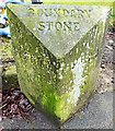
Old Boundary Marker by Singleton Road, Bury Parish
Parish Boundary Marker by the UC road, in parish of Bury (Bury District), Singleton Road, on wide grass at back of footpath outside The Oaks, 76 Singleton Road.
Inscription reads:-
: PRESTWICH : : BOUNDARY / STONE : : SALFORD :
Grade II listed. List Entry Number: 1386168
https://historicengland.org.uk/listing/the-list/list-entry/1386168
Surveyed
Milestone Society National ID: LA_PRESAL01pb.
Image: © Milestone Society
Taken: Unknown
0.20 miles
7
King's Road
Image: © Peter McDermott
Taken: 1 Jun 2020
0.21 miles
8
Singleton Road, Broughton Park
Image: © Peter Whatley
Taken: 28 Feb 2009
0.21 miles
9
Old Boundary Marker by the A665, Bury Old Road, Salford parish
Parish Boundary Marker by the A665, in parish of Salford (Salford District), Bury Old Road, approx. 25 yards West of cast iron milestone LA_MABYO03
Image and opposite 183 Bury Old Road, Salford.
Inscription reads:-
: PRESTWICH : : BOUNDARY / STONE : : SALFORD :
Grade II listed.
List Entry Number: 1386104 https://historicengland.org.uk/listing/the-list/list-entry/1386104
Surveyed
Milestone Society National ID: LA_MABYO03pb
Image: © Milestone Society
Taken: Unknown
0.24 miles
10
Old Milepost by the A665, Bury Old Road, Salford parish
Cast iron post by the A665, in parish of SALFORD (SALFORD District), Bury Old Road, opposite No. 181, opposite cultural centre, built into wall, on North side of road. St Anne's post (very weathered) erected by the District Council in the 19th century. Approx. 25 yards East of stone Boundary Marker: LA_MABYO03pb
Image
Inscription reads:-
TO
ST. ANNES
SQUARE
3
MILES
{coat of arms}
Milestone Society National ID: LA_MABYO03.
Image: © Mike Faherty
Taken: 19 Oct 2009
0.25 miles


