IMAGES TAKEN NEAR TO
Woodthorpe Grange, MANCHESTER, M25 0GU
Introduction
This page details the photographs taken nearby to Woodthorpe Grange, M25 0GU by members of the Geograph project.
The Geograph project started in 2005 with the aim of publishing, organising and preserving representative images for every square kilometre of Great Britain, Ireland and the Isle of Man.

There are currently over 7.5m images from over14,400 individuals and you can help contribute to the project by visiting https://www.geograph.org.uk
Image Map
Images are licensed for reuse under creativecommons.org/licenses/by-sa/2.0
Notes
- Clicking on the map will re-center to the selected point.
- The higher the marker number, the further away the image location is from the centre of the postcode.
Image Listing (15 Images Found)
Images are licensed for reuse under creativecommons.org/licenses/by-sa/2.0
Image
Details
Distance
2
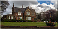
The Woodthorpe
The Woodthorpe public house.
Image: © Peter McDermott
Taken: 3 May 2015
0.12 miles
3
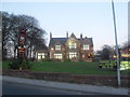
Woodthorpe Hotel
Former family home of Sir Edward Holt in the late 1800s, the Woodthorpe is a flagship Holts pub located just across the road from Heaton Park. https://www.joseph-holt.com/pubs/woodthorpe-hotel
Image
Image: © Gerald England
Taken: 28 Aug 2021
0.12 miles
4
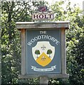
Sign of The Woodthorpe
Sign for The Woodthorpe Image
Image: © Gerald England
Taken: 28 Aug 2021
0.12 miles
5
St Gabriel's Church, Sedgley Park, Prestwich
Image: © Alexander P Kapp
Taken: 19 Sep 2005
0.16 miles
6
St Gabriel's Church, Prestwich
The building was designed by the firm of Isaac Taylor and W. Cecil Young and is Grade II listed. The listing states: "St. Gabriel's is a carefully considered amalgam of 17th century brick and timber motifs with a massing derived from contemporary Dutch and North German sources that make for a fine, distinctive composition. It is one of the Firm's finest churches."
The church is built from brown Blockley brick with a Westmoreland slate roof. It has a squat west tower and is built on a "basilica" plan with an eight bay nave with clerestory windows.
Image: © Tricia Neal
Taken: 14 Sep 2013
0.18 miles
7
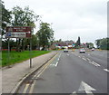
Sheepfoot Lane
Looking west towards the junction with Bury Old Road.
Image: © JThomas
Taken: 10 Sep 2018
0.20 miles
8
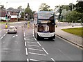
Metrolink Replacement Service, Sheepfoot Lane
Stagecoach Manchester 19279 (MX08 GRU), an Alexander Dennis Trident with Alexander Dennis Enviro400 H47/33F bodywork operating a Metrolink Replacement Service between Bury and Manchester Piccadilly. The bus is seen here on Sheepfoot Lane, between the Heaton Park and Bowker Vale tram stops.
Image: © David Dixon
Taken: 6 Oct 2013
0.21 miles
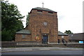
9
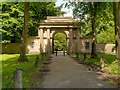
Heaton Park, Grand Lodge Gatehouse
The Grand Lodge gatehouse was built in 1807 together with a 4-mile long boundary wall as part of the alterations to the park that had been laid in the 1700s as a setting for Heaton Hall. Following the alterations, the gatehouse became the main formal entrance to the estate.
The lodge keeper’s living quarters are on either side of the arch, joined by steps across the top.
Image: © David Dixon
Taken: 18 Jun 2012
0.22 miles
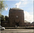
10
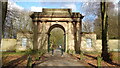
Grand Lodge
A southern entrance for Heaton Hall on Sheepfoot Lane
Image: © Kevin Waterhouse
Taken: 15 Feb 2018
0.22 miles