IMAGES TAKEN NEAR TO
Castle Hill Road, MANCHESTER, M25 0FR
Introduction
This page details the photographs taken nearby to Castle Hill Road, M25 0FR by members of the Geograph project.
The Geograph project started in 2005 with the aim of publishing, organising and preserving representative images for every square kilometre of Great Britain, Ireland and the Isle of Man.

There are currently over 7.5m images from over14,400 individuals and you can help contribute to the project by visiting https://www.geograph.org.uk
Image Map
Images are licensed for reuse under creativecommons.org/licenses/by-sa/2.0
Notes
- Clicking on the map will re-center to the selected point.
- The higher the marker number, the further away the image location is from the centre of the postcode.
Image Listing (11 Images Found)
Images are licensed for reuse under creativecommons.org/licenses/by-sa/2.0
Image
Details
Distance
1
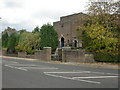
Broughton, synagogue
Holy Law Synagogue on Bury New Road. http://www.manchester2002-uk.com/worship/worship7.html
Image: © Mike Faherty
Taken: 19 Oct 2009
0.15 miles
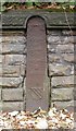
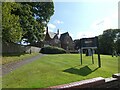
3
Old Boundary Marker by Singleton Road, Bury Parish
Parish Boundary Marker by the UC road, in parish of Bury (Bury District), Singleton Road, on wide grass at back of footpath outside The Oaks, 76 Singleton Road.
Inscription reads:-
: PRESTWICH : : BOUNDARY / STONE : : SALFORD :
Grade II listed. List Entry Number: 1386168
https://historicengland.org.uk/listing/the-list/list-entry/1386168
Surveyed
Milestone Society National ID: LA_PRESAL01pb.
Image: © Milestone Society
Taken: Unknown
0.22 miles
4
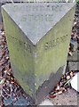
Old Boundary Marker by the A665, Bury Old Road, Salford parish
Parish Boundary Marker by the A665, in parish of Salford (Salford District), Bury Old Road, approx. 25 yards West of cast iron milestone LA_MABYO03 Image and opposite 183 Bury Old Road, Salford.
Inscription reads:-
: PRESTWICH : : BOUNDARY / STONE : : SALFORD :
Grade II listed.
List Entry Number: 1386104 https://historicengland.org.uk/listing/the-list/list-entry/1386104
Surveyed
Milestone Society National ID: LA_MABYO03pb
Image: © Milestone Society
Taken: Unknown
0.23 miles
6
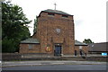
St Gabriel's Church, Sedgley Park, Prestwich
Image: © Alexander P Kapp
Taken: 19 Sep 2005
0.24 miles
7
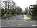
Old Milepost by the A665, Bury Old Road, Salford parish
Cast iron post by the A665, in parish of SALFORD (SALFORD District), Bury Old Road, opposite No. 181, opposite cultural centre, built into wall, on North side of road. St Anne's post (very weathered) erected by the District Council in the 19th century. Approx. 25 yards East of stone Boundary Marker: LA_MABYO03pb Image
Inscription reads:-
TO
ST. ANNES
SQUARE
3
MILES
{coat of arms}
Milestone Society National ID: LA_MABYO03.
Image: © Mike Faherty
Taken: 19 Oct 2009
0.24 miles
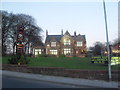
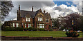
8
Building Off Singleton Road, Broughton Park
A fine example of the style of dwelling once commonplace in the area.
Image: © Peter Whatley
Taken: 28 Feb 2009
0.25 miles
9
The Woodthorpe
The Woodthorpe public house.
Image: © Peter McDermott
Taken: 3 May 2015
0.25 miles
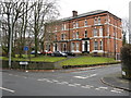
10
Woodthorpe Hotel
Former family home of Sir Edward Holt in the late 1800s, the Woodthorpe is a flagship Holts pub located just across the road from Heaton Park. https://www.joseph-holt.com/pubs/woodthorpe-hotel
Image
Image: © Gerald England
Taken: 28 Aug 2021
0.25 miles