IMAGES TAKEN NEAR TO
Middleton, MANCHESTER, M24 6XF
Introduction
This page details the photographs taken nearby to M24 6XF by members of the Geograph project.
The Geograph project started in 2005 with the aim of publishing, organising and preserving representative images for every square kilometre of Great Britain, Ireland and the Isle of Man.

There are currently over 7.5m images from over14,400 individuals and you can help contribute to the project by visiting https://www.geograph.org.uk
Image Map
Images are licensed for reuse under creativecommons.org/licenses/by-sa/2.0
Notes
- Clicking on the map will re-center to the selected point.
- The higher the marker number, the further away the image location is from the centre of the postcode.
Image Listing (9 Images Found)
Images are licensed for reuse under creativecommons.org/licenses/by-sa/2.0
Image
Details
Distance
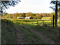
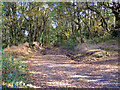
4
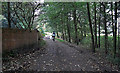
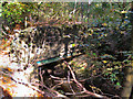
Trub Brook
View from the track used by Rochdale Way around Hopwood Hall
Image: © Kevin Waterhouse
Taken: 3 Dec 2022
0.13 miles
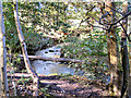
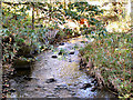
5
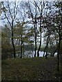
The Butts, Hopwood Hall
This wide track skirts the east side of Hopwood Hall College near Middleton. View from where the track crosses Trub Brook.
Image: © michael ely
Taken: 27 Sep 2009
0.13 miles
8
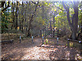
Path And Gate To Hopwood Woods Nature Reserve
Gate and path into Hopwood Woods Nature Reserve, from Oaken Bank Road.
Image: © David Dixon
Taken: 13 Oct 2010
0.21 miles
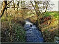
9
Oaken Bank Wood
Despite its name, Oaken Bank Road is only a track at this point.
Image: © David Dixon
Taken: 13 Oct 2010
0.23 miles