IMAGES TAKEN NEAR TO
Furness Road, MANCHESTER, M24 6EQ
Introduction
This page details the photographs taken nearby to Furness Road, M24 6EQ by members of the Geograph project.
The Geograph project started in 2005 with the aim of publishing, organising and preserving representative images for every square kilometre of Great Britain, Ireland and the Isle of Man.

There are currently over 7.5m images from over14,400 individuals and you can help contribute to the project by visiting https://www.geograph.org.uk
Image Map
Images are licensed for reuse under creativecommons.org/licenses/by-sa/2.0
Notes
- Clicking on the map will re-center to the selected point.
- The higher the marker number, the further away the image location is from the centre of the postcode.
Image Listing (5 Images Found)
Images are licensed for reuse under creativecommons.org/licenses/by-sa/2.0
Image
Details
Distance
1
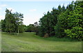
An area of green space in Hollins
This land is between Tintern Road and Whalley Road, around a small clough, and is entirely surrounded by housing.
Image: © Bill Boaden
Taken: 16 Jun 2010
0.16 miles
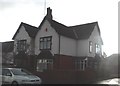
3

Middleton Cricket Club - Entrance
The sign at the Hollin Lane (not to be confused with Bamford-Fieldhouse CC) entrance to Middleton CC.
Image: © BatAndBall
Taken: 13 Jun 2012
0.21 miles
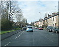
5
Tintern Road, Hollins
A large area of housing with both council and private.
Image: © Bill Boaden
Taken: 16 Jun 2010
0.22 miles