IMAGES TAKEN NEAR TO
Morton Street, MANCHESTER, M24 6AX
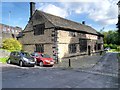
Introduction
This page details the photographs taken nearby to Morton Street, M24 6AX by members of the Geograph project.
The Geograph project started in 2005 with the aim of publishing, organising and preserving representative images for every square kilometre of Great Britain, Ireland and the Isle of Man.

There are currently over 7.5m images from over14,400 individuals and you can help contribute to the project by visiting https://www.geograph.org.uk
Image Map
Images are licensed for reuse under creativecommons.org/licenses/by-sa/2.0
Notes
- Clicking on the map will re-center to the selected point.
- The higher the marker number, the further away the image location is from the centre of the postcode.
Image Listing (99 Images Found)
Images are licensed for reuse under creativecommons.org/licenses/by-sa/2.0
Image
Details
Distance
1
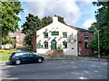
Ring O Bells, St Leonard's Square, Middleton
Image: © Alexander P Kapp
Taken: 19 Feb 2008
0.08 miles
2
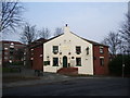
The Ring O'Bells, St Leonard's Square
The Ring o’ Bells is reputed to be one of the oldest buildings in Middleton; historically, the pub’s foundations are thought to date back to Saxon times.
The pub is said to be haunted by the ghost of a sad Cavalier known as Edward, and by poltergeists. According to "The Middleton Heritage Trail" leaflet (www.middleton-heritage-trail.org.uk ) the ghost is said to throw stones, glasses and other objects around the bar while its footsteps have been heard around the pub.
Image: © David Dixon
Taken: 14 Sep 2013
0.08 miles
3
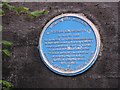
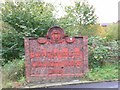
Middleton and The Peterloo Massacre
Plaque commemorating Middleton's connection with the 1819 Peterloo Massacre in nearby Manchester. A meeting of people demanding Parliamentary reform gathering in St Peter's Fields, Manchester was broken up by troops and the leaders arrested. Eleven demonstrators were killed and many injured.
Image: © Keith Williamson
Taken: 11 Nov 2005
0.08 miles
4
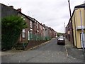
Middleton
Morton Street, Middleton at its junction with Clarke Brow.
Image: © Keith Williamson
Taken: 11 Nov 2005
0.08 miles
5
Middleton Electricity Works
All that remains of this works on Boarshaw Road, Middleton.
Image: © Keith Williamson
Taken: 11 Nov 2005
0.08 miles
6
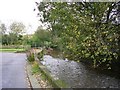
Whit Brook
Whit Brook, a tributary of the River Irk running close to the Old Grammar School, Middleton.
Image: © Keith Williamson
Taken: 11 Nov 2005
0.10 miles
7
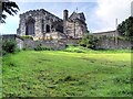
St Leonard's Parish Church, Middleton
A notable feature of the exterior of St Leonard's Church is the curious wooden belfry; St Leonard's Church has one of the three remaining wooden church towers in existence in Britain. Described locally as "a wooden steeple for stubborn people", the wooden belfry was added on top of the mediæval tower in 1666, to enable a new set of bells to be added. It has been suggested that wood was used because the sandy foundations of the tower would not bear the additional weight of a stone extension. Another theory is that the wooden structure would allow a sweeter tone to be heard from the bells.
Image: © David Dixon
Taken: 14 Sep 2013
0.10 miles
8
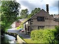
Middleton, The Old Grammar School and Whit Brook
Image: © David Dixon
Taken: 14 Sep 2013
0.10 miles
10
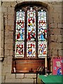
St Leonard's Church Middleton
This is the "other" window in the sanctuary. Sited in the north wall of the sanctuary, opposite the much more famous Image
Image: © David Dixon
Taken: 14 Sep 2013
0.10 miles