IMAGES TAKEN NEAR TO
Brattray Drive, MANCHESTER, M24 5WW
Introduction
This page details the photographs taken nearby to Brattray Drive, M24 5WW by members of the Geograph project.
The Geograph project started in 2005 with the aim of publishing, organising and preserving representative images for every square kilometre of Great Britain, Ireland and the Isle of Man.

There are currently over 7.5m images from over14,400 individuals and you can help contribute to the project by visiting https://www.geograph.org.uk
Image Map
Images are licensed for reuse under creativecommons.org/licenses/by-sa/2.0
Notes
- Clicking on the map will re-center to the selected point.
- The higher the marker number, the further away the image location is from the centre of the postcode.
Image Listing (7 Images Found)
Images are licensed for reuse under creativecommons.org/licenses/by-sa/2.0
Image
Details
Distance
1
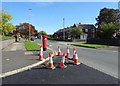
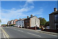
Windermere Road, Middleton
Showing position of Postbox No. M24 636.
See Image] for postbox.
Image: © JThomas
Taken: 25 Sep 2018
0.18 miles
2
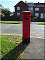
Elizabeth II postbox on Windermere Road, Middleton
Postbox No. M24 636.
See Image] for context.
Image: © JThomas
Taken: 25 Sep 2018
0.19 miles
3

Fields at Langley
Looking northwest across the fields from Langley Lane, Middleton. Open land to the north of the built-up area. SD86270756.
Image: © Keith Williamson
Taken: 5 Oct 2005
0.20 miles
4
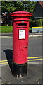
George V postbox on Langdale Drive Middleton
Postbox No. M24 441.
See Image] for context.
Image: © JThomas
Taken: 25 Sep 2018
0.21 miles
5
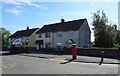
Houses on Langdale Drive, Middleton
Showing position of Postbox No. M24 441.
See Image] for postbox.
Image: © JThomas
Taken: 25 Sep 2018
0.22 miles
7
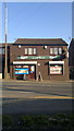
Hebers Off Licence & Mini Market
Hebers Off Licence & Mini Market - also branded as Zak's Off Licence - is a commercial premises in the Hebers area of Middleton, Greater Manchester, England.
Image: © Steven Haslington
Taken: 16 Nov 2011
0.25 miles