IMAGES TAKEN NEAR TO
Martindale Close, MANCHESTER, M24 5TH
Introduction
This page details the photographs taken nearby to Martindale Close, M24 5TH by members of the Geograph project.
The Geograph project started in 2005 with the aim of publishing, organising and preserving representative images for every square kilometre of Great Britain, Ireland and the Isle of Man.

There are currently over 7.5m images from over14,400 individuals and you can help contribute to the project by visiting https://www.geograph.org.uk
Image Map
Images are licensed for reuse under creativecommons.org/licenses/by-sa/2.0
Notes
- Clicking on the map will re-center to the selected point.
- The higher the marker number, the further away the image location is from the centre of the postcode.
Image Listing (12 Images Found)
Images are licensed for reuse under creativecommons.org/licenses/by-sa/2.0
Image
Details
Distance
1
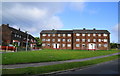
A block of flats in Langley
Viewed from Martindale Crescent.
Image: © Bill Boaden
Taken: 10 Jun 2010
0.07 miles
2
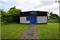
The River Community Church
A small independent church on Martindale Crescent, Langley.
Image: © Bill Boaden
Taken: 10 Jun 2010
0.08 miles
3
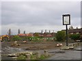
Swept Clean!
All that remains of this former public house is the sign bearing its name - The New Broom!
Image: © Keith Williamson
Taken: 1 Dec 2005
0.12 miles
4
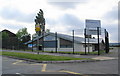
Langley Library
It is sharing this new building with a Surestart Centre. This is some of the evidence of money being pumped into this estate.
Image: © Bill Boaden
Taken: 10 Jun 2010
0.18 miles
5
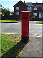
Elizabeth II postbox on Windermere Road, Middleton
Postbox No. M24 636.
See Image] for context.
Image: © JThomas
Taken: 25 Sep 2018
0.19 miles
6
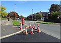
Windermere Road, Middleton
Showing position of Postbox No. M24 636.
See Image] for postbox.
Image: © JThomas
Taken: 25 Sep 2018
0.20 miles
7
The Tavern, Wood Street, Middleton
Image: © Alexander P Kapp
Taken: 22 Jan 2010
0.23 miles
8

Bus stop and shelter on Wood Street, Middleton
Looking north west.
Image: © JThomas
Taken: 25 Sep 2018
0.23 miles
9
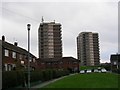
Highrise Accommodation at Langley
One of Europe's largest council housing estates, Langley was originally purchased by Manchester Corporation to establish a reservoir. The development of water resources in the Lake District made such a scheme unnecessary and Langley was used to re-house the thousands of people made homeless by the Manchester's post-war slum clearance programme.
Image: © Keith Williamson
Taken: 1 Dec 2005
0.24 miles
