IMAGES TAKEN NEAR TO
Borrowdale Road, MANCHESTER, M24 5QG
Introduction
This page details the photographs taken nearby to Borrowdale Road, M24 5QG by members of the Geograph project.
The Geograph project started in 2005 with the aim of publishing, organising and preserving representative images for every square kilometre of Great Britain, Ireland and the Isle of Man.

There are currently over 7.5m images from over14,400 individuals and you can help contribute to the project by visiting https://www.geograph.org.uk
Image Map
Images are licensed for reuse under creativecommons.org/licenses/by-sa/2.0
Notes
- Clicking on the map will re-center to the selected point.
- The higher the marker number, the further away the image location is from the centre of the postcode.
Image Listing (18 Images Found)
Images are licensed for reuse under creativecommons.org/licenses/by-sa/2.0
Image
Details
Distance

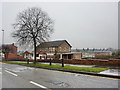
2

Mosedale Road, Middleton
Looking north east.
Image: © JThomas
Taken: 25 Sep 2018
0.13 miles
3
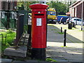
Elizabeth II postbox on Wood Street, Middleton
Postbox No. M24 678.
Image: © JThomas
Taken: 25 Sep 2018
0.14 miles
4
The Tavern, Wood Street, Middleton
Image: © Alexander P Kapp
Taken: 22 Jan 2010
0.15 miles

6

Our Lady of the Assumption Catholic Church, Langley, Middleton
Image: © Alexander P Kapp
Taken: 19 Aug 2005
0.17 miles
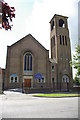
7
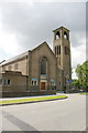
Our Lady of the Assumption Catholic Church, Langley, Middleton
Image: © Alexander P Kapp
Taken: 19 Aug 2005
0.17 miles
8
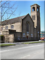
Our Lady of the Assumption Catholic Church
Wood Street, Langley.
Image: © David Dixon
Taken: 21 Apr 2010
0.17 miles
9
Our Lady of the Assumption Catholic Church, Langley, Middleton
Image: © Alexander P Kapp
Taken: 19 Aug 2005
0.17 miles
10

Bus stop and shelter on Wood Street, Middleton
Looking north west.
Image: © JThomas
Taken: 25 Sep 2018
0.17 miles