IMAGES TAKEN NEAR TO
Greystoke Drive, MANCHESTER, M24 5GP
Introduction
This page details the photographs taken nearby to Greystoke Drive, M24 5GP by members of the Geograph project.
The Geograph project started in 2005 with the aim of publishing, organising and preserving representative images for every square kilometre of Great Britain, Ireland and the Isle of Man.

There are currently over 7.5m images from over14,400 individuals and you can help contribute to the project by visiting https://www.geograph.org.uk
Image Map
Images are licensed for reuse under creativecommons.org/licenses/by-sa/2.0
Notes
- Clicking on the map will re-center to the selected point.
- The higher the marker number, the further away the image location is from the centre of the postcode.
Image Listing (24 Images Found)
Images are licensed for reuse under creativecommons.org/licenses/by-sa/2.0
Image
Details
Distance

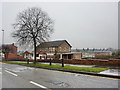
2

Mosedale Road, Middleton
Looking north east.
Image: © JThomas
Taken: 25 Sep 2018
0.07 miles
3
The Tavern, Wood Street, Middleton
Image: © Alexander P Kapp
Taken: 22 Jan 2010
0.09 miles
4
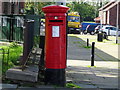
Elizabeth II postbox on Wood Street, Middleton
Postbox No. M24 678.
Image: © JThomas
Taken: 25 Sep 2018
0.09 miles

6

Bus stop and shelter on Wood Street, Middleton
Looking north west.
Image: © JThomas
Taken: 25 Sep 2018
0.11 miles
7
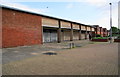
Empty shop units in Lakeland Court
Part of this block is due for demolition. Almost all the roads on this estate have a Lakeland theme, but generally do not carry the association. The road straight ahead here is Lingmell Close, but it is a world apart from Lingmell overlooking Wasdale.
Image: © Bill Boaden
Taken: 10 Jun 2010
0.13 miles
8
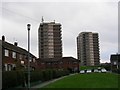
Highrise Accommodation at Langley
One of Europe's largest council housing estates, Langley was originally purchased by Manchester Corporation to establish a reservoir. The development of water resources in the Lake District made such a scheme unnecessary and Langley was used to re-house the thousands of people made homeless by the Manchester's post-war slum clearance programme.
Image: © Keith Williamson
Taken: 1 Dec 2005
0.17 miles
9
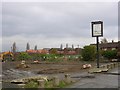
Swept Clean!
All that remains of this former public house is the sign bearing its name - The New Broom!
Image: © Keith Williamson
Taken: 1 Dec 2005
0.17 miles
10
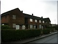
Urban degeneration
Boarded-up houses on Helvellyn Drive, Langley
Image: © Keith Williamson
Taken: 1 Dec 2005
0.18 miles