IMAGES TAKEN NEAR TO
Towncroft Avenue, MANCHESTER, M24 5DB
Introduction
This page details the photographs taken nearby to Towncroft Avenue, M24 5DB by members of the Geograph project.
The Geograph project started in 2005 with the aim of publishing, organising and preserving representative images for every square kilometre of Great Britain, Ireland and the Isle of Man.

There are currently over 7.5m images from over14,400 individuals and you can help contribute to the project by visiting https://www.geograph.org.uk
Image Map
Images are licensed for reuse under creativecommons.org/licenses/by-sa/2.0
Notes
- Clicking on the map will re-center to the selected point.
- The higher the marker number, the further away the image location is from the centre of the postcode.
Image Listing (12 Images Found)
Images are licensed for reuse under creativecommons.org/licenses/by-sa/2.0
Image
Details
Distance
1
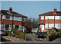
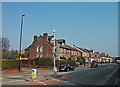
Houses on Towncroft Avenue
Towncroft Avenue ends here as a cul-de-sac where semis nos 83,85, 87 and 89 are at the head of it.
Image: © michael ely
Taken: 24 Mar 2011
0.02 miles
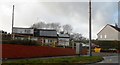
2
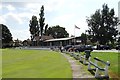
The paviilion - Middleton Cricket Club
Image: © Neil Theasby
Taken: 24 Jul 2014
0.11 miles
3
Middleton Cricket Club - Pavilion
The pavilion at Middleton CC's Towncroft ground.
The club have three sides in the Central Lancashire League.
Image: © BatAndBall
Taken: 13 Jun 2012
0.12 miles
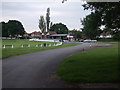
5
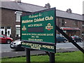
Middleton Cricket Club - Entrance
The sign at the Hollin Lane (not to be confused with Bamford-Fieldhouse CC) entrance to Middleton CC.
Image: © BatAndBall
Taken: 13 Jun 2012
0.16 miles
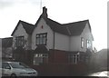
8
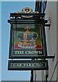
The Crown, Middleton
A John Willie Lees' pub on Long Street (A664) opposite Towncroft Avenue.
Image: © michael ely
Taken: 24 Mar 2011
0.20 miles
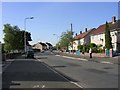
9
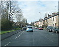
A664, Long Street, Middleton
The main road here has a junction with Towncroft Avenue.
Image: © michael ely
Taken: 24 Mar 2011
0.20 miles
10
Langley.
Looking down Langdale Drive, Langley from its junction with Hollin Lane. Langley is a large housing estate to the northwest of Middleton and is one of Europe's largest council housing estates. Langley was bought by Manchester Corporation to establish a reservoir. The development of Manchester's water supply in the Lake District made it surplus to requirements and the land was used for re-housing the thousands of people made homeless by the city's slum clearance programme after the Second World War.
Image: © Keith Williamson
Taken: 5 Oct 2005
0.23 miles