IMAGES TAKEN NEAR TO
Top Schwabe Street, MANCHESTER, M24 4TQ
Introduction
This page details the photographs taken nearby to Top Schwabe Street, M24 4TQ by members of the Geograph project.
The Geograph project started in 2005 with the aim of publishing, organising and preserving representative images for every square kilometre of Great Britain, Ireland and the Isle of Man.

There are currently over 7.5m images from over14,400 individuals and you can help contribute to the project by visiting https://www.geograph.org.uk
Image Map
Images are licensed for reuse under creativecommons.org/licenses/by-sa/2.0
Notes
- Clicking on the map will re-center to the selected point.
- The higher the marker number, the further away the image location is from the centre of the postcode.
Image Listing (20 Images Found)
Images are licensed for reuse under creativecommons.org/licenses/by-sa/2.0
Image
Details
Distance
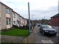
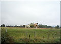
1
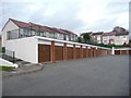
Garages and houses in Hilton Walk
A hillside estate in Rhodes, off Boardman Lane.
Image: © Christine Johnstone
Taken: 12 Nov 2010
0.11 miles
2
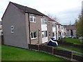
Houses in Wells Close
Seen from Hilton Walk.
Image: © Christine Johnstone
Taken: 12 Nov 2010
0.12 miles
3
Wells Close, Rhodes
A hillside housing estate alongside Boardman Lane.
Image: © Christine Johnstone
Taken: 12 Nov 2010
0.13 miles
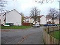
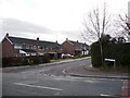
4
Boardman Lane, Rhodes
Viewed from Hilton Walk.
Image: © Christine Johnstone
Taken: 12 Nov 2010
0.14 miles
5
Schoolside Lane, Rhodes
Seen from Boardman Lane.
Image: © Christine Johnstone
Taken: 12 Nov 2010
0.16 miles
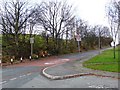
6
Boardman Lane, Rhodes
Dropping down past houses and a primary school to the A576.
Image: © Christine Johnstone
Taken: 12 Nov 2010
0.18 miles
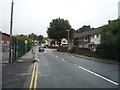
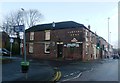
9
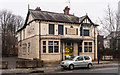
Barbers Arms
The Barbers Arms public house near Middleton.
Image: © Peter McDermott
Taken: 27 Dec 2014
0.21 miles