IMAGES TAKEN NEAR TO
Irk Gardens, MANCHESTER, M24 4TJ
Introduction
This page details the photographs taken nearby to Irk Gardens, M24 4TJ by members of the Geograph project.
The Geograph project started in 2005 with the aim of publishing, organising and preserving representative images for every square kilometre of Great Britain, Ireland and the Isle of Man.

There are currently over 7.5m images from over14,400 individuals and you can help contribute to the project by visiting https://www.geograph.org.uk
Image Map
Images are licensed for reuse under creativecommons.org/licenses/by-sa/2.0
Notes
- Clicking on the map will re-center to the selected point.
- The higher the marker number, the further away the image location is from the centre of the postcode.
Image Listing (44 Images Found)
Images are licensed for reuse under creativecommons.org/licenses/by-sa/2.0
Image
Details
Distance
2
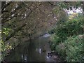
The Irk from Booth Bridge
Looking upstream to the east, from the bridge carrying Boothroyden Road over the River Irk. SD85090504
Image: © Keith Williamson
Taken: 6 Oct 2005
0.05 miles
3
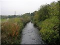
River Irk from Booth Bridge
Looking downstream to the west, from the bridge carrying Boothroyden Road over the River Irk. SD85090503.
Image: © Keith Williamson
Taken: 6 Oct 2005
0.05 miles
4
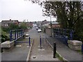
Booth Bridge
This bridge crosses the Irk to the south of Rhodes and carries Boothroyden Road over the river. Since the building of the M60 Motorway Boothroyden Road has been split into two halves and linked by a footbridge and footpath over the motorway, hence the narrowing works evident on the bridge here. SD85100502.
Image: © Keith Williamson
Taken: 6 Oct 2005
0.05 miles

6
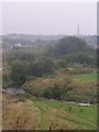
Irk Valley
Looking west along the valley of the River Irk from Boothroyden Road, Higher Blackley. The BT mast in Heaton Park is clearly visible and the Temple in Heaton Park can be seen top left, above the white house and bridge over the M60 motorway. SD85060497.
Image: © Keith Williamson
Taken: 6 Oct 2005
0.09 miles
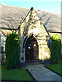
8

All Saints Church, Rhodes, Nameboard
Image: © Alexander P Kapp
Taken: 5 Dec 2012
0.09 miles
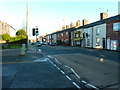
10
M60 Motorway, Middleton
Looking along the M60 Motorway in an easterly direction from Boothroyden Road footbridge. SD85080495.
Image: © Keith Williamson
Taken: 6 Oct 2005
0.09 miles