IMAGES TAKEN NEAR TO
Heywood Old Road, MANCHESTER, M24 4SD
Introduction
This page details the photographs taken nearby to Heywood Old Road, M24 4SD by members of the Geograph project.
The Geograph project started in 2005 with the aim of publishing, organising and preserving representative images for every square kilometre of Great Britain, Ireland and the Isle of Man.

There are currently over 7.5m images from over14,400 individuals and you can help contribute to the project by visiting https://www.geograph.org.uk
Image Map (Loading...)


Getting Data...Please wait
Leaflet Map data © OpenStreetMap
Images are licensed for reuse under creativecommons.org/licenses/by-sa/2.0
Notes
- Clicking on the map will re-center to the selected point.
- The higher the marker number, the further away the image location is from the centre of the postcode.
Image Listing (7 Images Found)
Images are licensed for reuse under creativecommons.org/licenses/by-sa/2.0
Image
Details
Distance
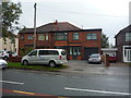
1
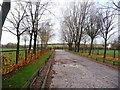
Entrance to car park
Looking towards the main road [A6045].
Image: © Christine Johnstone
Taken: 12 Nov 2010
0.07 miles

3
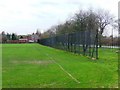
Sports fencing along the A6045
Designed to keep balls out of the traffic.
Image: © Christine Johnstone
Taken: 12 Nov 2010
0.08 miles
4
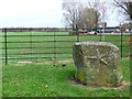
A6045 verge, near car park entrance
What is the significance of the star on the boulder?
Image: © Christine Johnstone
Taken: 12 Nov 2010
0.08 miles
5
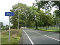
Cycle lane beside Heywood Old Road (A6045)
Looking north east.
Image: © JThomas
Taken: 17 Sep 2018
0.15 miles
7
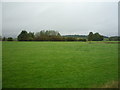
Grazing, Green Lane End
Off Heywood Old Road (A6045).
Image: © JThomas
Taken: 17 Sep 2018
0.21 miles