IMAGES TAKEN NEAR TO
Manchester Old Road, MANCHESTER, M24 4EA
Introduction
This page details the photographs taken nearby to Manchester Old Road, M24 4EA by members of the Geograph project.
The Geograph project started in 2005 with the aim of publishing, organising and preserving representative images for every square kilometre of Great Britain, Ireland and the Isle of Man.

There are currently over 7.5m images from over14,400 individuals and you can help contribute to the project by visiting https://www.geograph.org.uk
Image Map
Images are licensed for reuse under creativecommons.org/licenses/by-sa/2.0
Notes
- Clicking on the map will re-center to the selected point.
- The higher the marker number, the further away the image location is from the centre of the postcode.
Image Listing (18 Images Found)
Images are licensed for reuse under creativecommons.org/licenses/by-sa/2.0
Image
Details
Distance
1
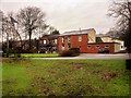
Parkfield House
Parkfield House in Middleton - offices for Chubb.
Image: © Peter McDermott
Taken: 27 Dec 2014
0.06 miles
2
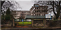
Parkfield House
This is the former Middleton Town Hall. Following the local government reorganisation of 1974, it was acquired by North West Water. It now belongs to Chubb.
Image: © Bill Boaden
Taken: 23 Apr 2010
0.06 miles
4
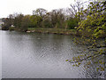
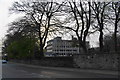
Rhodes Lodges (Eastern)
The most easterly of the Rhodes lodges.
Image: © David Dixon
Taken: 23 Apr 2010
0.12 miles
5
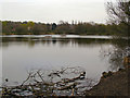
Rhodes Lodges (East)
The most easterly of the lodges at Rhodes.
Image: © David Dixon
Taken: 23 Apr 2010
0.15 miles
8
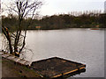
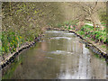
Rhodes Lodges
The most easterly of the lodges at Rhodes.
Image: © David Dixon
Taken: 23 Apr 2010
0.17 miles