IMAGES TAKEN NEAR TO
Brownrigg Close, MANCHESTER, M24 4BU
Introduction
This page details the photographs taken nearby to Brownrigg Close, M24 4BU by members of the Geograph project.
The Geograph project started in 2005 with the aim of publishing, organising and preserving representative images for every square kilometre of Great Britain, Ireland and the Isle of Man.

There are currently over 7.5m images from over14,400 individuals and you can help contribute to the project by visiting https://www.geograph.org.uk
Image Map
Images are licensed for reuse under creativecommons.org/licenses/by-sa/2.0
Notes
- Clicking on the map will re-center to the selected point.
- The higher the marker number, the further away the image location is from the centre of the postcode.
Image Listing (6 Images Found)
Images are licensed for reuse under creativecommons.org/licenses/by-sa/2.0
Image
Details
Distance
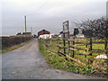
1
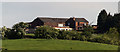
Rhodes Green Farm
View of Rhodes Green Farm.
Image: © Peter McDermott
Taken: 13 May 2018
0.19 miles
3
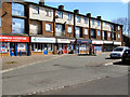
Bowness Shops
Row of shops on Bowness Road, Langley.
Image: © David Dixon
Taken: 21 Apr 2010
0.19 miles
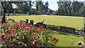
5
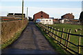
Rhodes Green Farm
Situated on a low hill above Rhodes.
Image: © Bill Boaden
Taken: 26 Dec 2012
0.23 miles