IMAGES TAKEN NEAR TO
Church Avenue, MANCHESTER, M24 2UA
Introduction
This page details the photographs taken nearby to Church Avenue, M24 2UA by members of the Geograph project.
The Geograph project started in 2005 with the aim of publishing, organising and preserving representative images for every square kilometre of Great Britain, Ireland and the Isle of Man.

There are currently over 7.5m images from over14,400 individuals and you can help contribute to the project by visiting https://www.geograph.org.uk
Image Map
Images are licensed for reuse under creativecommons.org/licenses/by-sa/2.0
Notes
- Clicking on the map will re-center to the selected point.
- The higher the marker number, the further away the image location is from the centre of the postcode.
Image Listing (43 Images Found)
Images are licensed for reuse under creativecommons.org/licenses/by-sa/2.0
Image
Details
Distance
1
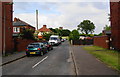
Church Avenue
It leads up towards St John's Church, Thornham.
Image: © Bill Boaden
Taken: 23 Jun 2010
0.03 miles
2
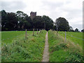
Footpath to St. John's Church, Thornham
This convenient and well-used path connects the church directly to the main Rochdale Road.
Image: © Dr Neil Clifton
Taken: 16 Sep 2004
0.04 miles
3
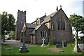
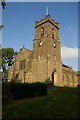
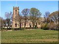
St John the Evangelist Church, Thornham
Image: © Alexander P Kapp
Taken: 17 Oct 2005
0.07 miles
4
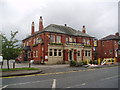
Hopwood Arms, near Castleton, Rochdale, Lancashire
Image: © Dr Neil Clifton
Taken: 19 Sep 2004
0.07 miles
5
St John the Evangelist Church, Thornham
Image: © Alexander P Kapp
Taken: 17 Oct 2005
0.08 miles
6
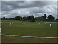
Thornham Cricket Club
Thornham Cricket Club play in the Lancashire County League.
St. Johns church can be seen in the background.
Image: © BatAndBall
Taken: 19 Jun 2011
0.08 miles
7
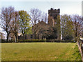
Church of St John the Evangelist, Thornham
The church viewed from Church Avenue.
Despite not having a church building, the parish of Thornham-with-Gravelhole was officially established on the 8th February 1896, offering its public worship at the school where it first began in 1841. The foundation stone of the church building was laid in 1906 and the almost completed building was consecrated on the 14th of November in 1907. The north aisle and tower were completed in 1914. Although the parish serves an area of suburban housing, between Rochdale and Middleton and the adjoining M62, the parish church stands in open countryside approached by a footpath from the main road, with vehicular access via an unmade lane (Thornham Lane).
http://www.stjohnthornham.org.uk/
Image: © David Dixon
Taken: 21 Apr 2010
0.08 miles
8
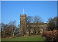
St John the Evangelist, Thornham
Looking northwest from an entrance on Thornham Lane. The foundation stone for this church was laid in 1906. The original church was built in 1841 and is 450 metres further up the lane where it is now St Johnn's C of E Primary School.
Image: © michael ely
Taken: 5 Feb 2007
0.08 miles
9
Church of St John the Evangelist, Thornham
The church viewed from Thornham Lane.
Despite not having a church building, the parish of Thornham-with-Gravelhole was officially established on the 8th February 1896, offering its public worship at the school where it first began in 1841. The foundation stone of the church building was laid in 1906 and the almost completed building was consecrated on the 14th of November in 1907. The north aisle and tower were completed in 1914. Although the parish serves an area of suburban housing, between Rochdale and Middleton and the adjoining M62, the parish church stands in open countryside approached by a footpath from the main road, with vehicular access via an unmade lane (Thornham Lane).
http://www.stjohnthornham.org.uk/
Image: © David Dixon
Taken: 21 Apr 2010
0.09 miles
10
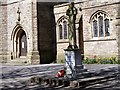
Thornham War Memorial
Standing in the grounds of the parish church (Image]).
Image: © David Dixon
Taken: 21 Apr 2010
0.09 miles