IMAGES TAKEN NEAR TO
Whitbrook Way, MANCHESTER, M24 2SS
Introduction
This page details the photographs taken nearby to Whitbrook Way, M24 2SS by members of the Geograph project.
The Geograph project started in 2005 with the aim of publishing, organising and preserving representative images for every square kilometre of Great Britain, Ireland and the Isle of Man.

There are currently over 7.5m images from over14,400 individuals and you can help contribute to the project by visiting https://www.geograph.org.uk
Image Map
Images are licensed for reuse under creativecommons.org/licenses/by-sa/2.0
Notes
- Clicking on the map will re-center to the selected point.
- The higher the marker number, the further away the image location is from the centre of the postcode.
Image Listing (46 Images Found)
Images are licensed for reuse under creativecommons.org/licenses/by-sa/2.0
Image
Details
Distance
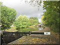
1
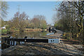
Lock #57 Rochdale Canal
Part of the four lock rise at Slattocks to the north of Middleton.
Image: © michael ely
Taken: 29 Mar 2012
0.04 miles
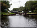
3
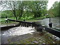
High water levels at Lock 57, Rochdale Canal
A lock is normally filled through ground or gate paddles [sluices]. Not straight over the top of the lock gate!
Image: © Christine Johnstone
Taken: 7 May 2014
0.04 miles
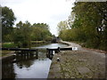
4
Slattocks Lock No 57, Rochdale Canal
Image: © Dr Neil Clifton
Taken: 16 Sep 2004
0.05 miles
5
Rochdale Canal, Lock 57 towards Lock 56
Image: © John Slater
Taken: 17 Oct 2013
0.05 miles
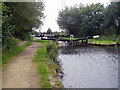
7
Slattocks Lock No 56, Rochdale Canal
Image: © Dr Neil Clifton
Taken: 16 Sep 2004
0.08 miles
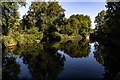
9
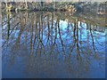
Reflections on the Rochdale Canal
In February sunshine south of Slattocks.
Image: © michael ely
Taken: 5 Feb 2007
0.10 miles
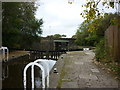
10
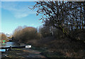
Rochdale Canal beyond lock 58
Looking north towards Slattocks.
Image: © michael ely
Taken: 3 Feb 2015
0.10 miles