IMAGES TAKEN NEAR TO
Rochdale Road, MANCHESTER, M24 2RN
Introduction
This page details the photographs taken nearby to Rochdale Road, M24 2RN by members of the Geograph project.
The Geograph project started in 2005 with the aim of publishing, organising and preserving representative images for every square kilometre of Great Britain, Ireland and the Isle of Man.

There are currently over 7.5m images from over14,400 individuals and you can help contribute to the project by visiting https://www.geograph.org.uk
Image Map
Images are licensed for reuse under creativecommons.org/licenses/by-sa/2.0
Notes
- Clicking on the map will re-center to the selected point.
- The higher the marker number, the further away the image location is from the centre of the postcode.
Image Listing (41 Images Found)
Images are licensed for reuse under creativecommons.org/licenses/by-sa/2.0
Image
Details
Distance
1
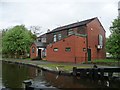
The Ship Inn, Slattocks
Turning its back on the canal it once served [and was named for].
Image: © Christine Johnstone
Taken: 7 May 2014
0.01 miles
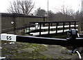
2
A full bywash at Lock 55, the Rochdale Canal
A bywash is an overflow that takes surplus water around a lock, rather than through it.
Image: © Christine Johnstone
Taken: 7 May 2014
0.02 miles
3
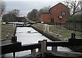
Rochdale Canal Lock No 55 Slattocks
Looking north. The Ship Inn pub can be seen on the towpath.
Image: © michael ely
Taken: 20 Jan 2010
0.02 miles
4
![2nd Laneside Lock [No 55], Rochdale Canal](https://s0.geograph.org.uk/geophotos/03/98/10/3981032_cb5d36d1_120x120.jpg)
2nd Laneside Lock [No 55], Rochdale Canal
The top gates are open to allow a boat to descend, but the canal is so full water is spilling over the tops of the bottom gates.
Image: © Christine Johnstone
Taken: 7 May 2014
0.02 miles
5
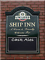
Ship Inn canal-side pub
This sign is seen from the towpath from where there is a rear entrance into the pub. The front door is on Manchester Road. The southern elevation of the pub can be seen here http://www.geograph.org.uk/photo/1671659
Image: © michael ely
Taken: 20 Jan 2010
0.03 miles
6
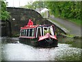
Narrowboat heading south from Bridge 66, Slattocks
A rainy day on the Rochdale Canal.
Image: © Christine Johnstone
Taken: 7 May 2014
0.03 miles
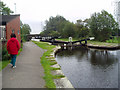
7

Slattocks Lock No 54 Rochdale Canal
A much photographed lock with the lock keeper's cottage alongside. This is the highest of five locks at Slattocks (near Middleton) that come in quick succession. This one, and lock 55, are to the north of the A664 - the other three are to the south.
Image: © michael ely
Taken: 19 Jan 2010
0.03 miles
8
Rochdale Canal Bridge No 67
Looking south from lock no 55. The stone bridge is bridge no 67 where the A664, Rochdale Road crosses the canal at Slattocks.
Image: © michael ely
Taken: 20 Jan 2010
0.04 miles
9
Slattocks Lock No 55, Rochdale Canal
Image: © Dr Neil Clifton
Taken: 16 Sep 2004
0.04 miles
10
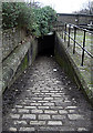
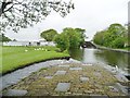
Rochdale Canal towpath Slattocks
This is where the towpath descends lock 55 to go under bridge no 67 (A664, Rochdale Road) at Slattocks. The towpath emerges on the other side of the bridge here http://www.geograph.org.uk/photo/330238
Image: © michael ely
Taken: 20 Jan 2010
0.04 miles