IMAGES TAKEN NEAR TO
Boarshaw Road, MANCHESTER, M24 2NH
Introduction
This page details the photographs taken nearby to Boarshaw Road, M24 2NH by members of the Geograph project.
The Geograph project started in 2005 with the aim of publishing, organising and preserving representative images for every square kilometre of Great Britain, Ireland and the Isle of Man.

There are currently over 7.5m images from over14,400 individuals and you can help contribute to the project by visiting https://www.geograph.org.uk
Image Map
Images are licensed for reuse under creativecommons.org/licenses/by-sa/2.0
Notes
- Clicking on the map will re-center to the selected point.
- The higher the marker number, the further away the image location is from the centre of the postcode.
Image Listing (11 Images Found)
Images are licensed for reuse under creativecommons.org/licenses/by-sa/2.0
Image
Details
Distance
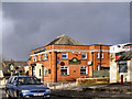
2
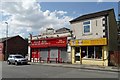
Business premises on Boarshaw Road, Middleton
"B RGAIN BOO" is a rather catchy shop name don't you think?
Image: © Neil Theasby
Taken: 24 Jul 2014
0.16 miles
3
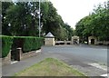
Entrance to Middleton Cemetery and Crematorium
Image: © Alexander P Kapp
Taken: 25 Jan 2010
0.17 miles
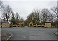
4
Boarshaw Community Primary School, Middleton
Image: © Alexander P Kapp
Taken: 25 Jan 2010
0.17 miles
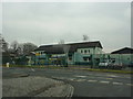
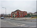
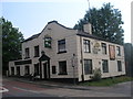
5
The Boarshaw
Public house on Stanycliffe Lane
Image: © David Dixon
Taken: 9 Feb 2010
0.18 miles
7
The Boarshaw, Stanycliffe Lane, Middleton
Image: © Alexander P Kapp
Taken: 25 Jan 2010
0.20 miles
10
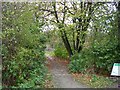
Boarshaw Clough
The entrance to Boarshaw Clough, Middleton. A recreational area and nature reserve formed from a derelict industrial area.
Image: © Keith Williamson
Taken: 11 Nov 2005
0.25 miles