IMAGES TAKEN NEAR TO
Pilkington Street, MANCHESTER, M24 2JJ
Introduction
This page details the photographs taken nearby to Pilkington Street, M24 2JJ by members of the Geograph project.
The Geograph project started in 2005 with the aim of publishing, organising and preserving representative images for every square kilometre of Great Britain, Ireland and the Isle of Man.

There are currently over 7.5m images from over14,400 individuals and you can help contribute to the project by visiting https://www.geograph.org.uk
Image Map
Images are licensed for reuse under creativecommons.org/licenses/by-sa/2.0
Notes
- Clicking on the map will re-center to the selected point.
- The higher the marker number, the further away the image location is from the centre of the postcode.
Image Listing (30 Images Found)
Images are licensed for reuse under creativecommons.org/licenses/by-sa/2.0
Image
Details
Distance
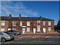
1

343 to 349 Oldham Road, Middleton
From left to right are house numbers 343 to 349 Oldham Road in Middleton, Greater Manchester, England.
Image: © Steven Haslington
Taken: 19 Nov 2013
0.06 miles
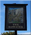
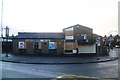
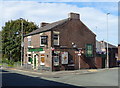
5
The Nowster
Public house on the corner of Kenyon Lane and Oldham Road.
Image: © David Dixon
Taken: 9 Feb 2010
0.07 miles
7
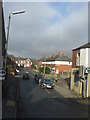
Middleton - Hilton Fold Lane from Oldham Road
Image: © Peter Whatley
Taken: 19 Jan 2011
0.08 miles
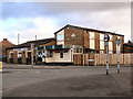
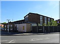
8
Now Not The Nowster
The Nowster is now closed and boarded up.
Image: © Anthony Parkes
Taken: 3 Dec 2011
0.08 miles
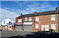
9
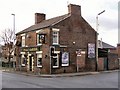
Jolly Carter
At the corner of Oldham Road and Hilton Fold Lane
Image: © David Dixon
Taken: 9 Feb 2010
0.09 miles
10
The Jolly Carter public house
On Oldham Road (A669).
Image: © JThomas
Taken: 25 Sep 2018
0.09 miles