IMAGES TAKEN NEAR TO
Worcester Road, MANCHESTER, M24 1WZ
Introduction
This page details the photographs taken nearby to Worcester Road, M24 1WZ by members of the Geograph project.
The Geograph project started in 2005 with the aim of publishing, organising and preserving representative images for every square kilometre of Great Britain, Ireland and the Isle of Man.

There are currently over 7.5m images from over14,400 individuals and you can help contribute to the project by visiting https://www.geograph.org.uk
Image Map
Images are licensed for reuse under creativecommons.org/licenses/by-sa/2.0
Notes
- Clicking on the map will re-center to the selected point.
- The higher the marker number, the further away the image location is from the centre of the postcode.
Image Listing (7 Images Found)
Images are licensed for reuse under creativecommons.org/licenses/by-sa/2.0
Image
Details
Distance
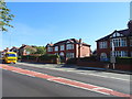
1
Mainway, Alkrington
Houses on Mainway in the Alkrington Garden Village area of Middleton, Greater Manchester.
Image: © Steven Haslington
Taken: 14 Sep 2016
0.20 miles
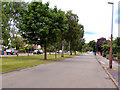
4
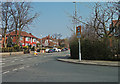
Manchester New Road, Alkrington
Looking north along the A664 from its junction with Mainway.
Image: © michael ely
Taken: 24 Mar 2011
0.22 miles

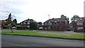
6

St Thomas More Roman Catholic Church, Alkrington
Image: © David Dixon
Taken: 6 Jul 2010
0.24 miles