IMAGES TAKEN NEAR TO
Kirkway, MANCHESTER, M24 1FL
Introduction
This page details the photographs taken nearby to Kirkway, M24 1FL by members of the Geograph project.
The Geograph project started in 2005 with the aim of publishing, organising and preserving representative images for every square kilometre of Great Britain, Ireland and the Isle of Man.

There are currently over 7.5m images from over14,400 individuals and you can help contribute to the project by visiting https://www.geograph.org.uk
Image Map
Images are licensed for reuse under creativecommons.org/licenses/by-sa/2.0
Notes
- Clicking on the map will re-center to the selected point.
- The higher the marker number, the further away the image location is from the centre of the postcode.
Image Listing (26 Images Found)
Images are licensed for reuse under creativecommons.org/licenses/by-sa/2.0
Image
Details
Distance
1
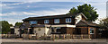
The Lancashire Fold
The Lancashire Fold public house.
Image: © Peter McDermott
Taken: 13 May 2018
0.09 miles
2
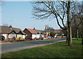
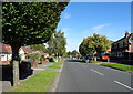
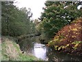
Kirkway, Middleton
Looking northeast towards its junction with Grimshaw Lane. The open area in the foreground is part of the Wince Brook woodland area.
Image: © michael ely
Taken: 24 Mar 2011
0.13 miles
4
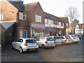
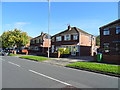
Alkrington - local shops at Mount Road roundabout
Image: © Peter Whatley
Taken: 19 Jan 2011
0.16 miles
6
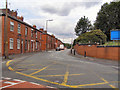
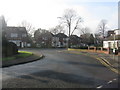
Townley Street
From the corner of Kirkway and Grimshaw Lane.
Image: © David Dixon
Taken: 6 Jul 2010
0.19 miles
10
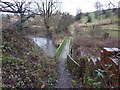
Wince Brook
Wince Brook, a tributary of the River Irk, running near Grimshaw Lane just south of Middleton town centre.
Image: © Keith Williamson
Taken: 11 Nov 2005
0.21 miles