IMAGES TAKEN NEAR TO
Mount Road, MANCHESTER, M24 1EX
Introduction
This page details the photographs taken nearby to Mount Road, M24 1EX by members of the Geograph project.
The Geograph project started in 2005 with the aim of publishing, organising and preserving representative images for every square kilometre of Great Britain, Ireland and the Isle of Man.

There are currently over 7.5m images from over14,400 individuals and you can help contribute to the project by visiting https://www.geograph.org.uk
Image Map
Images are licensed for reuse under creativecommons.org/licenses/by-sa/2.0
Notes
- Clicking on the map will re-center to the selected point.
- The higher the marker number, the further away the image location is from the centre of the postcode.
Image Listing (19 Images Found)
Images are licensed for reuse under creativecommons.org/licenses/by-sa/2.0
Image
Details
Distance
1
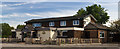
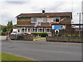
The Lancashire Fold
The Lancashire Fold public house.
Image: © Peter McDermott
Taken: 13 May 2018
0.18 miles
3
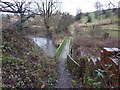
Wince Brook
Wince Brook, a tributary of the River Irk, running near Grimshaw Lane just south of Middleton town centre.
Image: © Keith Williamson
Taken: 11 Nov 2005
0.20 miles
4
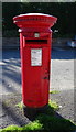
Elizabeth II postbox on Kingsway, Middleton
Postbox No. M24 673.
See Image] for context.
Image: © JThomas
Taken: 25 Sep 2018
0.20 miles
5
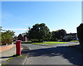
Kingsway, Middleton
Showing position of Postbox No. M24 673.
See Image] for postbox.
Image: © JThomas
Taken: 25 Sep 2018
0.21 miles
8
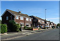
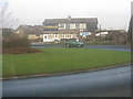
Houses on Kingsway, Alkrington Garden Village
Image: © JThomas
Taken: 25 Sep 2018
0.21 miles
9
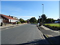
Bus stop on Kingsway, Alkrington Garden Village
Looking east.
Image: © JThomas
Taken: 25 Sep 2018
0.21 miles