IMAGES TAKEN NEAR TO
Farmway, MANCHESTER, M24 1DL
Introduction
This page details the photographs taken nearby to Farmway, M24 1DL by members of the Geograph project.
The Geograph project started in 2005 with the aim of publishing, organising and preserving representative images for every square kilometre of Great Britain, Ireland and the Isle of Man.

There are currently over 7.5m images from over14,400 individuals and you can help contribute to the project by visiting https://www.geograph.org.uk
Image Map
Images are licensed for reuse under creativecommons.org/licenses/by-sa/2.0
Notes
- Clicking on the map will re-center to the selected point.
- The higher the marker number, the further away the image location is from the centre of the postcode.
Image Listing (27 Images Found)
Images are licensed for reuse under creativecommons.org/licenses/by-sa/2.0
Image
Details
Distance
1
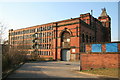
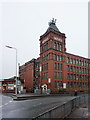
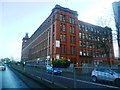
Warwick Mill, Middleton
Listed Grade II. Strongly detailed Edwardian Mill with massive engine house and "hotel de ville" water tower.
Image: © Chris Allen
Taken: 16 Feb 2008
0.11 miles
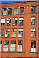
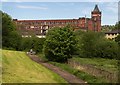
7
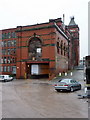
Warwick Mill, Middleton, Engine house
Image: © Alexander P Kapp
Taken: 22 Jan 2010
0.16 miles
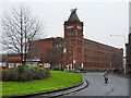
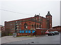
10
Warwick Mill
Warwick Mill in Middleton.
Image: © Peter McDermott
Taken: 13 May 2018
0.16 miles