IMAGES TAKEN NEAR TO
Booth Street, MANCHESTER, M24 1DD
Introduction
This page details the photographs taken nearby to Booth Street, M24 1DD by members of the Geograph project.
The Geograph project started in 2005 with the aim of publishing, organising and preserving representative images for every square kilometre of Great Britain, Ireland and the Isle of Man.

There are currently over 7.5m images from over14,400 individuals and you can help contribute to the project by visiting https://www.geograph.org.uk
Image Map (Loading...)


Getting Data...Please wait
Leaflet Map data © OpenStreetMap
Images are licensed for reuse under creativecommons.org/licenses/by-sa/2.0
Notes
- Clicking on the map will re-center to the selected point.
- The higher the marker number, the further away the image location is from the centre of the postcode.
Image Listing (81 Images Found)
Images are licensed for reuse under creativecommons.org/licenses/by-sa/2.0
Image
Details
Distance
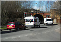
1
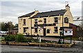
Radclyffe Arms
The Radclyffe Arms public house. See also David Dixon's picture Image
Image: © Peter McDermott
Taken: 17 Oct 2014
0.03 miles
2
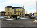
Radclyffe Arms
The Radclyffe Arms, Grimshaw Lane, Middleton Junction.
Image: © David Dixon
Taken: 7 Dec 2010
0.03 miles
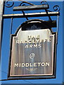
3
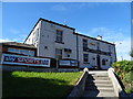
The Radclyffe Arms, Middleton
On Grimshaw Lane.
Image: © JThomas
Taken: 25 Sep 2018
0.03 miles
5
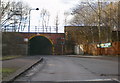
Railway Bridge over Grimshaw Lane
Carries the Manchester to Rochdale Railway over Grimshaw Lane
Image: © Alexander P Kapp
Taken: 10 Feb 2009
0.05 miles
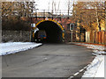
6
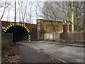
Railway bridge, Middleton Junction
Foxdenton Lane (B6189) narrows as it passes beneath the railway hence the traffic lights to control the traffic under the bridge.
Image: © michael ely
Taken: 18 Mar 2011
0.06 miles
7
Grimshaw Lane Railway Bridge
The railway bridge over Grimshaw Lane (B6189) at Middleton Junction.
Image: © David Dixon
Taken: 7 Dec 2010
0.06 miles
8
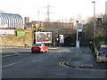
Middleton Junction railway bridge
The bridge at the former station is a legacy of the earliest days of railway constructions. Effectively a single lane tunnel under the divergence between the lines to Rochdale and Oldham (via the Werneth incline), it has long been a local landmark.
Image: © Peter Whatley
Taken: 19 Jan 2011
0.06 miles
9
Middleton Junction railway station (site), Greater Manchester
Opened in 1842 as "Middleton" by the Manchester & Leeds Railway, soon to become part of the Lancashire & Yorkshire Railway, this station's name changed to "Middleton Junction" in 1852. It closed in 1966.
View north west from Grimshaw Lane. The southern end of the former platforms were just to the right of the bridge. See also Image
Image: © Nigel Thompson
Taken: 11 Mar 2019
0.07 miles
10
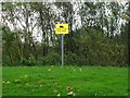
Warning!
Sign warning of a concealed steep slope down to Wince Brook by Greengate, Middleton.
Image: © Keith Williamson
Taken: 11 Nov 2005
0.08 miles