IMAGES TAKEN NEAR TO
Victoria Street, MANCHESTER, M24 1BY
Introduction
This page details the photographs taken nearby to Victoria Street, M24 1BY by members of the Geograph project.
The Geograph project started in 2005 with the aim of publishing, organising and preserving representative images for every square kilometre of Great Britain, Ireland and the Isle of Man.

There are currently over 7.5m images from over14,400 individuals and you can help contribute to the project by visiting https://www.geograph.org.uk
Image Map
Images are licensed for reuse under creativecommons.org/licenses/by-sa/2.0
Notes
- Clicking on the map will re-center to the selected point.
- The higher the marker number, the further away the image location is from the centre of the postcode.
Image Listing (76 Images Found)
Images are licensed for reuse under creativecommons.org/licenses/by-sa/2.0
Image
Details
Distance
1
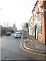
The Brunswick
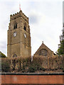
A friendly bikers' pub still with a taste for heavy rock. The tower of St Michael's Church, Alkrington-cum-Tonge is behind.
Image: © Bill Boaden
Taken: 23 Apr 2010
0.02 miles
2
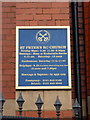
St Peter's RC Church, Middleton, Sign
Image: © Alexander P Kapp
Taken: 22 Jan 2010
0.04 miles
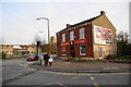
4

The Brunswick, Middleton
Free house on Townley Street.
Image: © JThomas
Taken: 25 Sep 2018
0.04 miles
5
Middleton - Lark Hill at Townley Street
Image: © Peter Whatley
Taken: 19 Jan 2011
0.05 miles
6

The Church of Jesus Christ of Later Day Saints, Middleton
Image: © Alexander P Kapp
Taken: 22 Jan 2010
0.07 miles
7
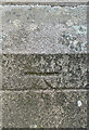
OS Cut Mark Middleton Church
https://www.bench-marks.org.uk/bm56971
Image: © thejackrustles
Taken: 18 Jul 2022
0.07 miles
8
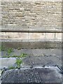
Location of OS Cut Mark Middleton Church
Image: © thejackrustles
Taken: 18 Jul 2022
0.07 miles
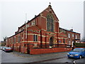
9
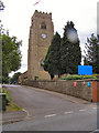
St Michael's CE Church
St Michael's Church, Townley St, Middleton.
Image: © David Dixon
Taken: 6 Jul 2010
0.08 miles