IMAGES TAKEN NEAR TO
Townley Street, MANCHESTER, M24 1AS
Introduction
This page details the photographs taken nearby to Townley Street, M24 1AS by members of the Geograph project.
The Geograph project started in 2005 with the aim of publishing, organising and preserving representative images for every square kilometre of Great Britain, Ireland and the Isle of Man.

There are currently over 7.5m images from over14,400 individuals and you can help contribute to the project by visiting https://www.geograph.org.uk
Image Map
Images are licensed for reuse under creativecommons.org/licenses/by-sa/2.0
Notes
- Clicking on the map will re-center to the selected point.
- The higher the marker number, the further away the image location is from the centre of the postcode.
Image Listing (147 Images Found)
Images are licensed for reuse under creativecommons.org/licenses/by-sa/2.0
Image
Details
Distance
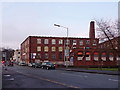
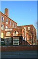
1
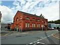
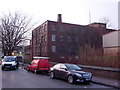
Former Electricity Department Offices
On Townley Street the electricity department of the former council when it generated its own power. The former railway station and yard is only a short distance away for coal deliveries and the River Irk flows past the site.
Image: © Kevin Waterhouse
Taken: 20 Aug 2023
0.02 miles
2
Electricity sub station on Townley Street, Middleton
Image: © Alexander P Kapp
Taken: 22 Jan 2010
0.03 miles
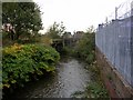
5

River Irk, Middleton
Looking upstream from Townley Street Bridge.
Image: © Keith Williamson
Taken: 11 Nov 2005
0.04 miles
6
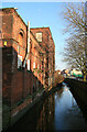
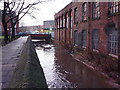
Lodge Mill and the River Irk, Middleton
Ramshackle complex in multiple occupancy. The closest building appears to be a former engine house. More recent views show increasing dereliction with missing windows.
Image: © Chris Allen
Taken: 16 Feb 2008
0.04 miles
7
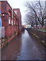
River Irk, Middleton
Looking downstream from the Townley Street Bridge. This river running towards Manchester was totally transformed by the Industrial Revolution; it runs through areas that became major industrial centres of the 19th and 20th Centuries. Following the decline of these industries the river and its surroundings were left derelict and polluted. In recent times regeneration schemes have been started that are steadily improving the areas involved.
Image: © Keith Williamson
Taken: 11 Nov 2005
0.04 miles
8
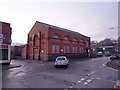
Lodge Mill, Townley street, Middleton
A former cotton mill that was in multiple occupancy. More recent views show increasing dereliction with missing windows. The closest part of the building was probably once an engine house.
Image: © Chris Allen
Taken: 16 Feb 2008
0.05 miles