IMAGES TAKEN NEAR TO
Claverton Road, MANCHESTER, M23 9SP
Introduction
This page details the photographs taken nearby to Claverton Road, M23 9SP by members of the Geograph project.
The Geograph project started in 2005 with the aim of publishing, organising and preserving representative images for every square kilometre of Great Britain, Ireland and the Isle of Man.

There are currently over 7.5m images from over14,400 individuals and you can help contribute to the project by visiting https://www.geograph.org.uk
Image Map
Images are licensed for reuse under creativecommons.org/licenses/by-sa/2.0
Notes
- Clicking on the map will re-center to the selected point.
- The higher the marker number, the further away the image location is from the centre of the postcode.
Image Listing (19 Images Found)
Images are licensed for reuse under creativecommons.org/licenses/by-sa/2.0
Image
Details
Distance
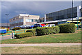
1
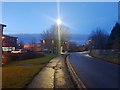
Floats Road
Looking along Floats Road near University Hospital of South Manchester.
Image: © DS Pugh
Taken: 21 Dec 2019
0.13 miles
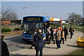
4
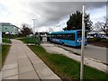
Bus stops at Wythenshawe Hospital
An Arriva bus outside Wythenshawe Hospital.
Image: © Gerald England
Taken: 1 Mar 2017
0.15 miles
7
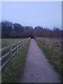
Path near Fairywell Wood
Looking towards Fairywell Wood on a path from Brooks Drive.
Image: © DS Pugh
Taken: 21 Dec 2019
0.18 miles
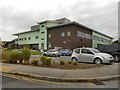
8
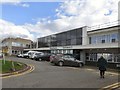
Wythenshawe Hospital
Outpatients Entrance 5.
Image: © Gerald England
Taken: 1 Mar 2017
0.19 miles
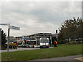
9
Outpatients Department, Wythenshawe Hospital
Image: © David Dixon
Taken: 8 Aug 2018
0.20 miles
10

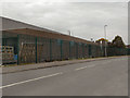
Roundthorn
Looking roughly east along Ledson Road on Roundthorn Industrial Estate, near Wythenshawe. SJ80418842
Image: © Keith Williamson
Taken: 18 Oct 2005
0.21 miles