IMAGES TAKEN NEAR TO
Floats Road, MANCHESTER, M23 9NF
Introduction
This page details the photographs taken nearby to Floats Road, M23 9NF by members of the Geograph project.
The Geograph project started in 2005 with the aim of publishing, organising and preserving representative images for every square kilometre of Great Britain, Ireland and the Isle of Man.

There are currently over 7.5m images from over14,400 individuals and you can help contribute to the project by visiting https://www.geograph.org.uk
Image Map
Images are licensed for reuse under creativecommons.org/licenses/by-sa/2.0
Notes
- Clicking on the map will re-center to the selected point.
- The higher the marker number, the further away the image location is from the centre of the postcode.
Image Listing (4 Images Found)
Images are licensed for reuse under creativecommons.org/licenses/by-sa/2.0
Image
Details
Distance
1

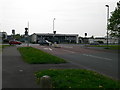
Roundthorn
Looking roughly east along Ledson Road on Roundthorn Industrial Estate, near Wythenshawe. SJ80418842
Image: © Keith Williamson
Taken: 18 Oct 2005
0.23 miles
2
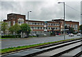
Southmoor House, Southmoor Road, Manchester
A 1930s block fronting Southmoor Industrial Estate. There is a further block to the right, Trafford House, and extensive sheds behind.
The tram runs in front.
Image: © Stephen Richards
Taken: 26 May 2016
0.23 miles