IMAGES TAKEN NEAR TO
Southmoor Road, MANCHESTER, M23 9LT
Introduction
This page details the photographs taken nearby to Southmoor Road, M23 9LT by members of the Geograph project.
The Geograph project started in 2005 with the aim of publishing, organising and preserving representative images for every square kilometre of Great Britain, Ireland and the Isle of Man.

There are currently over 7.5m images from over14,400 individuals and you can help contribute to the project by visiting https://www.geograph.org.uk
Image Map
Images are licensed for reuse under creativecommons.org/licenses/by-sa/2.0
Notes
- Clicking on the map will re-center to the selected point.
- The higher the marker number, the further away the image location is from the centre of the postcode.
Image Listing (24 Images Found)
Images are licensed for reuse under creativecommons.org/licenses/by-sa/2.0
Image
Details
Distance
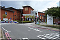
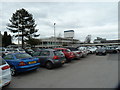
1
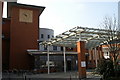
University Hospital of South Manchester, Wythenshawe
In the complex of University Hospital of South Manchester, in the Wythenshawe area of Manchester, Greater Manchester, England.
Image: © Steven Haslington
Taken: 2 Aug 2011
0.03 miles
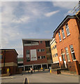
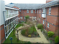
4
Maternity Hospital car park
Wythenshawe
Image: © Anthony O'Neil
Taken: 21 Mar 2016
0.06 miles
6
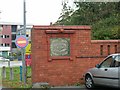
Baguley Sanatorium
The remains of the boundary wall and lodge gateway of Baguley Sanatorium, now Wythenshawe Hospital. The sanatorium was commissioned as a hospital for the treatment of infectious diseases and opened in 1902. In 1912 it was given over to treatment of TB patients only.
Image: © Keith Williamson
Taken: 18 Oct 2005
0.09 miles
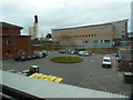
7
Wythenshawe Hospital
A general view of the southern aspect of Wythenshawe Hospital. The hospital occupies a substantial area in the northern half of this grid square, and as much again in the southern half of the square to the north (SJ8088). Taken from SJ80608779.
Image: © Keith Williamson
Taken: 18 Oct 2005
0.09 miles
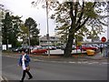
9
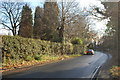
Floats Road, Wythenshawe
Floats Road runs to the west and south of Wythenshawe Hospital (which is behind the hedge on the right here). This is looking towards its junction with Dobbinetts Lane.
Image: © Trevor Harris
Taken: 5 Dec 2014
0.10 miles