IMAGES TAKEN NEAR TO
Rothermere Walk, MANCHESTER, M23 9BF
Introduction
This page details the photographs taken nearby to Rothermere Walk, M23 9BF by members of the Geograph project.
The Geograph project started in 2005 with the aim of publishing, organising and preserving representative images for every square kilometre of Great Britain, Ireland and the Isle of Man.

There are currently over 7.5m images from over14,400 individuals and you can help contribute to the project by visiting https://www.geograph.org.uk
Image Map
Images are licensed for reuse under creativecommons.org/licenses/by-sa/2.0
Notes
- Clicking on the map will re-center to the selected point.
- The higher the marker number, the further away the image location is from the centre of the postcode.
Image Listing (6 Images Found)
Images are licensed for reuse under creativecommons.org/licenses/by-sa/2.0
Image
Details
Distance
1
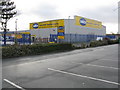
Selco, Baguley
Builders' Supplies on Timpson Road, next door to Tesco.
Image: © Peter Whatley
Taken: 23 Jan 2009
0.11 miles
2
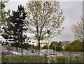
Trees in the car park
In between the trees behind the fence on Altrincham Road are cars visiting Baguley's Tesco.
Image: © Gerald England
Taken: 17 May 2012
0.15 miles
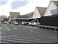

5
Tesco's Back Door
Goods entrances to the Tesco superstore on Timpson Road, Baguley.
Image: © Peter Whatley
Taken: 23 Jan 2009
0.22 miles
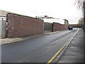
6
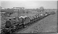
Westbound freight train approaching Baguley Station
As Image, view eastward, towards Stockport (Tiviot Dale) and Godley Junction; Cheshire Lines (CLC) main line Glazebrook - Godley Junction. The Class H freight is headed by Hughes/Fowler 5P4F 2-6-0 No. 42924. Beyond is Timpson's Shoe Works.
Image: © Ben Brooksbank
Taken: 5 May 1965
0.25 miles