IMAGES TAKEN NEAR TO
Briarwood Avenue, MANCHESTER, M23 9AY
Introduction
This page details the photographs taken nearby to Briarwood Avenue, M23 9AY by members of the Geograph project.
The Geograph project started in 2005 with the aim of publishing, organising and preserving representative images for every square kilometre of Great Britain, Ireland and the Isle of Man.

There are currently over 7.5m images from over14,400 individuals and you can help contribute to the project by visiting https://www.geograph.org.uk
Image Map (Loading...)


Getting Data...Please wait
Leaflet Map data © OpenStreetMap
Images are licensed for reuse under creativecommons.org/licenses/by-sa/2.0
Notes
- Clicking on the map will re-center to the selected point.
- The higher the marker number, the further away the image location is from the centre of the postcode.
Image Listing (5 Images Found)
Images are licensed for reuse under creativecommons.org/licenses/by-sa/2.0
Image
Details
Distance
1
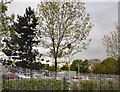
Trees in the car park
In between the trees behind the fence on Altrincham Road are cars visiting Baguley's Tesco.
Image: © Gerald England
Taken: 17 May 2012
0.20 miles
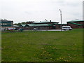
3
Brookway High School, Baguley
Sited on the corner of Moor Road and Altrincham Road
Image: © Eirian Evans
Taken: 23 Apr 2009
0.23 miles
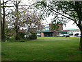
5
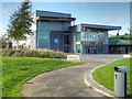
Manchester Health Academy, Wythenshawe
Manchester Health Academy http://www.manchesterhealthacademy.org.uk/ is a mixed-sex secondary school in Wythenshawe, which opened in September 2009 replacing the former Brookway High School & Sports College.
Image: © David Dixon
Taken: 3 Nov 2014
0.25 miles