IMAGES TAKEN NEAR TO
Scout Drive, MANCHESTER, M23 2SH
Introduction
This page details the photographs taken nearby to Scout Drive, M23 2SH by members of the Geograph project.
The Geograph project started in 2005 with the aim of publishing, organising and preserving representative images for every square kilometre of Great Britain, Ireland and the Isle of Man.

There are currently over 7.5m images from over14,400 individuals and you can help contribute to the project by visiting https://www.geograph.org.uk
Image Map
Images are licensed for reuse under creativecommons.org/licenses/by-sa/2.0
Notes
- Clicking on the map will re-center to the selected point.
- The higher the marker number, the further away the image location is from the centre of the postcode.
Image Listing (12 Images Found)
Images are licensed for reuse under creativecommons.org/licenses/by-sa/2.0
Image
Details
Distance
1
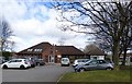
The Maples Medical Centre
The Maples Medical Centre http://www.themaplesmc.co.uk/ at Newall Green.
Image: © Gerald England
Taken: 9 Mar 2017
0.08 miles
2
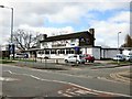
The Newall Green
A Joseph Holt's pub on the estate of the same name.
Image: © Gerald England
Taken: 9 Mar 2017
0.08 miles
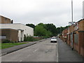
3
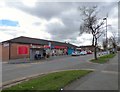
Shops on Greenbrow Road
At Newall Green. Post Office services are available inside the "One-Stop" shop.
Image: © Gerald England
Taken: 9 Mar 2017
0.10 miles
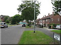
4
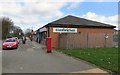
Greenbrow Road
The postbox Image used to be outside Newall Green Post Office. PO services are now available inside the "One-Stop" shop Image
Image: © Gerald England
Taken: 9 Mar 2017
0.10 miles
5
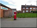
GR Postbox (M23 735)
On Greenbrow Road Image, Newall Green.
Image: © Gerald England
Taken: 9 Mar 2017
0.10 miles
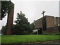
9
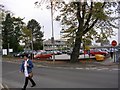
Wythenshawe Hospital
A general view of the southern aspect of Wythenshawe Hospital. The hospital occupies a substantial area in the northern half of this grid square, and as much again in the southern half of the square to the north (SJ8088). Taken from SJ80608779.
Image: © Keith Williamson
Taken: 18 Oct 2005
0.21 miles
10
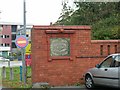
Baguley Sanatorium
The remains of the boundary wall and lodge gateway of Baguley Sanatorium, now Wythenshawe Hospital. The sanatorium was commissioned as a hospital for the treatment of infectious diseases and opened in 1902. In 1912 it was given over to treatment of TB patients only.
Image: © Keith Williamson
Taken: 18 Oct 2005
0.21 miles