IMAGES TAKEN NEAR TO
Telham Walk, MANCHESTER, M23 2QA
Introduction
This page details the photographs taken nearby to Telham Walk, M23 2QA by members of the Geograph project.
The Geograph project started in 2005 with the aim of publishing, organising and preserving representative images for every square kilometre of Great Britain, Ireland and the Isle of Man.

There are currently over 7.5m images from over14,400 individuals and you can help contribute to the project by visiting https://www.geograph.org.uk
Image Map
Images are licensed for reuse under creativecommons.org/licenses/by-sa/2.0
Notes
- Clicking on the map will re-center to the selected point.
- The higher the marker number, the further away the image location is from the centre of the postcode.
Image Listing (13 Images Found)
Images are licensed for reuse under creativecommons.org/licenses/by-sa/2.0
Image
Details
Distance
1
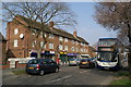
Avebury Road
Off Hollyhedge Road near Martinscroft tram stop.
Image: © Gerald England
Taken: 27 Jun 2015
0.01 miles
2
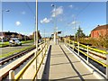
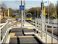
Metrolink Airport Line, Martinscroft Tram Stop
The line runs alongside the north side of Hollyhedge Road. Martinscroft stop is adjacent to St Martin’s Church; it has an island platform with ramps down to foot track crossings at both ends.
Image: © David Dixon
Taken: 3 Nov 2014
0.02 miles
3
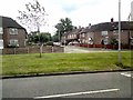
Church of St Martin
On Blackcarr Road and apparently not in use with services transferred to the church hall
Image: © Kevin Waterhouse
Taken: 2 May 2023
0.05 miles
4
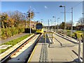
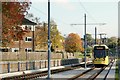
Metrolink Airport Line, Tram Approaching Martinscroft
An inbound tram approaches Martinscroft. The line runs alongside the north side of Hollyhedge Road. Martinscroft stop is adjacent to St Martin’s Church; it has an island platform with ramps down to foot track crossings at both ends.
Image: © David Dixon
Taken: 3 Nov 2014
0.05 miles
5
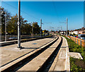
Metrolink Airport Line, Martinscroft
Metrolink tram 3062 leaves Martiscroft, on its journey towards Manchester Airport.
Here, the line runs on the north side of Hollyhedge Road. Martinscroft stop is adjacent to St Martin’s Church; it has an island platform with ramps down to foot track crossings at both ends.
Image: © David Dixon
Taken: 3 Nov 2014
0.06 miles
6
Metrolink
Metrolink line near Hollyhedge Road.
Image: © Peter McDermott
Taken: 12 Oct 2014
0.06 miles
7
Metrolink
The new Metrolink line in Wythenshawe.
Image: © Peter McDermott
Taken: 16 Aug 2014
0.06 miles
8
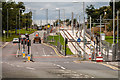
Tram approaching Martinscroft
On the western section of Hollyhedge Road, the tram runs on separate tracks alongside the road.
Image: © Alan Murray-Rust
Taken: 26 Oct 2015
0.08 miles
9
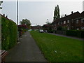
Belford Walk, leading to Baguley Hall Primary School
Image: © Eirian Evans
Taken: 23 Apr 2009
0.20 miles