IMAGES TAKEN NEAR TO
Floatshall Road, MANCHESTER, M23 1WF
Introduction
This page details the photographs taken nearby to Floatshall Road, M23 1WF by members of the Geograph project.
The Geograph project started in 2005 with the aim of publishing, organising and preserving representative images for every square kilometre of Great Britain, Ireland and the Isle of Man.

There are currently over 7.5m images from over14,400 individuals and you can help contribute to the project by visiting https://www.geograph.org.uk
Image Map
Images are licensed for reuse under creativecommons.org/licenses/by-sa/2.0
Notes
- Clicking on the map will re-center to the selected point.
- The higher the marker number, the further away the image location is from the centre of the postcode.
Image Listing (5 Images Found)
Images are licensed for reuse under creativecommons.org/licenses/by-sa/2.0
Image
Details
Distance
1
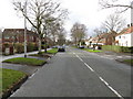
Baguley - Floatshall Road, looking west
Image: © Peter Whatley
Taken: 23 Jan 2009
0.05 miles
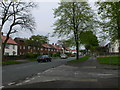
4
Baguley - Floatshall Road, looking east
Image: © Peter Whatley
Taken: 23 Jan 2009
0.15 miles
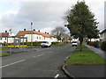
5
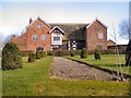
Baguley Hall
Wythenshawe-the largest municipal Estate in Europe at the time-mushroomed around the old Hall at Baguley from the late 1940's. The original timber-framed building was constructed in the 1350's. It is hoped that the Hall will be re-opened to the public later this year, after being closed and unoccupied since the 1950's.
Image: © Roger May
Taken: 20 Feb 2006
0.22 miles