IMAGES TAKEN NEAR TO
Saxfield Drive, MANCHESTER, M23 1PY
Introduction
This page details the photographs taken nearby to Saxfield Drive, M23 1PY by members of the Geograph project.
The Geograph project started in 2005 with the aim of publishing, organising and preserving representative images for every square kilometre of Great Britain, Ireland and the Isle of Man.

There are currently over 7.5m images from over14,400 individuals and you can help contribute to the project by visiting https://www.geograph.org.uk
Image Map
Images are licensed for reuse under creativecommons.org/licenses/by-sa/2.0
Notes
- Clicking on the map will re-center to the selected point.
- The higher the marker number, the further away the image location is from the centre of the postcode.
Image Listing (8 Images Found)
Images are licensed for reuse under creativecommons.org/licenses/by-sa/2.0
Image
Details
Distance
1
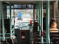
Service #199 on the M60
The "Trent" bus service #199 is a half-hourly service from Manchester Airport to Buxton which uses the M60 motorway between the airport and Stockport and then the A6 to Buxton.
Image: © Gerald England
Taken: 26 Feb 2003
0.13 miles
2
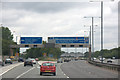
M56 at Wythenshawe
Junction 3 westbound.
Image: © Mike Pennington
Taken: 25 Jul 2010
0.14 miles

5
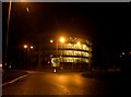
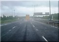
M56 joins the A560 in Wythenshawe
Not sure what this building is, but I thought it looked great.
Image: © Gary Barber
Taken: 6 Apr 2005
0.19 miles
6
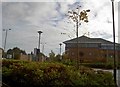
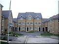
The Open University
Office complex from the Royal's car park.
Image: © Steve Fareham
Taken: 17 Oct 2008
0.20 miles
7
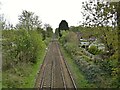
Railway view towards Stockport
From the bridge on Hall Lane across the Altrincham to Stockport line
Image: © Kevin Waterhouse
Taken: 2 May 2023
0.23 miles