IMAGES TAKEN NEAR TO
Rawpool Gardens, MANCHESTER, M23 1BN
Introduction
This page details the photographs taken nearby to Rawpool Gardens, M23 1BN by members of the Geograph project.
The Geograph project started in 2005 with the aim of publishing, organising and preserving representative images for every square kilometre of Great Britain, Ireland and the Isle of Man.

There are currently over 7.5m images from over14,400 individuals and you can help contribute to the project by visiting https://www.geograph.org.uk
Image Map
Images are licensed for reuse under creativecommons.org/licenses/by-sa/2.0
Notes
- Clicking on the map will re-center to the selected point.
- The higher the marker number, the further away the image location is from the centre of the postcode.
Image Listing (7 Images Found)
Images are licensed for reuse under creativecommons.org/licenses/by-sa/2.0
Image
Details
Distance
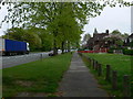
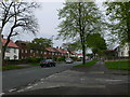
2
Footpath to Westgate Gardens
Footpath leading from the bus stop on Altrincham Road, Baguley leading to Westgate Gardens.
Image: © Gerald England
Taken: 17 May 2012
0.14 miles
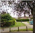
5
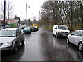
Side road off Hall Lane, Baguley
This short access road down to the Stockport-Altrincham railway line provides access to local shops just off Hall Lane.
Image: © Peter Whatley
Taken: 8 Dec 2008
0.23 miles
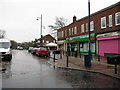
6
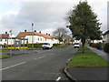
Baguley - Floatshall Road, looking east
Image: © Peter Whatley
Taken: 23 Jan 2009
0.24 miles