IMAGES TAKEN NEAR TO
Welbury Road, MANCHESTER, M23 0JN
Introduction
This page details the photographs taken nearby to Welbury Road, M23 0JN by members of the Geograph project.
The Geograph project started in 2005 with the aim of publishing, organising and preserving representative images for every square kilometre of Great Britain, Ireland and the Isle of Man.

There are currently over 7.5m images from over14,400 individuals and you can help contribute to the project by visiting https://www.geograph.org.uk
Image Map
Images are licensed for reuse under creativecommons.org/licenses/by-sa/2.0
Notes
- Clicking on the map will re-center to the selected point.
- The higher the marker number, the further away the image location is from the centre of the postcode.
Image Listing (9 Images Found)
Images are licensed for reuse under creativecommons.org/licenses/by-sa/2.0
Image
Details
Distance
1
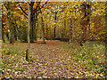
Nan Nook Wood
The north west corner of Nan Nook Wood, next to Wythenshawe Road.
Image: © David Dixon
Taken: 13 Nov 2012
0.21 miles
2
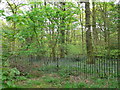
Nan Nook Wood
At the north-westerly part of Wythenshawe Park.
Image: © Eirian Evans
Taken: 23 Apr 2009
0.22 miles
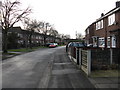
3
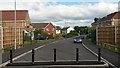
Street blocked by Manchester Airport Metrolink extension
Image: © David Martin
Taken: 17 Jul 2015
0.22 miles
4
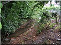
Baguley Brook
Looking north from culvert entrance on Wythenshawe Road. SJ80539013.
Image: © Keith Williamson
Taken: 18 Oct 2005
0.23 miles
6
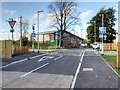
Bordley Walk
The Metrolink line to Manchester Airport crosses Bordley Walk near the Wythenshawe Park tram stop.
Image: © David Dixon
Taken: 3 Nov 2014
0.24 miles
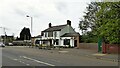
7
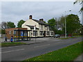
The Gardener's Arms, Northern Moor
On Wythenshawe Road.
Image: © Eirian Evans
Taken: 23 Apr 2009
0.25 miles
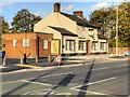
9
The Gardner's Arms
On Wythenshawe Road with the Metrolink tram station behind
Image: © Kevin Waterhouse
Taken: 2 May 2023
0.25 miles