IMAGES TAKEN NEAR TO
Greenham Road, MANCHESTER, M23 0JL
Introduction
This page details the photographs taken nearby to Greenham Road, M23 0JL by members of the Geograph project.
The Geograph project started in 2005 with the aim of publishing, organising and preserving representative images for every square kilometre of Great Britain, Ireland and the Isle of Man.

There are currently over 7.5m images from over14,400 individuals and you can help contribute to the project by visiting https://www.geograph.org.uk
Image Map
Images are licensed for reuse under creativecommons.org/licenses/by-sa/2.0
Notes
- Clicking on the map will re-center to the selected point.
- The higher the marker number, the further away the image location is from the centre of the postcode.
Image Listing (12 Images Found)
Images are licensed for reuse under creativecommons.org/licenses/by-sa/2.0
Image
Details
Distance
1
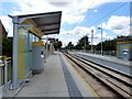
Northern Moor tram stop
On the line to the airport. On this day, however, no trams were operating due to earlier vandalism of the line at Chorlton Image
Image: © Gerald England
Taken: 4 Jul 2015
0.21 miles
4
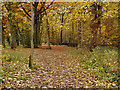
Nan Nook Wood
The north west corner of Nan Nook Wood, next to Wythenshawe Road.
Image: © David Dixon
Taken: 13 Nov 2012
0.23 miles
5
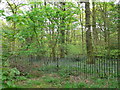
Nan Nook Wood
At the north-westerly part of Wythenshawe Park.
Image: © Eirian Evans
Taken: 23 Apr 2009
0.23 miles
6
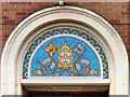
St Aidan's Church (detail)
Above the west door to Image
Image: © David Dixon
Taken: 13 Nov 2012
0.23 miles
7
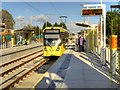
Metrolink Manchester Airport Line, Northern Moor Tram Stop
Metrolink Bombardier tram number 3078 arrives at the outbound platform of the Northern Moor tram stop.
The Northern Moor tram stop is situated just off Sale Road, behind Kerscott Road. It has two facing platforms for inbound (ie travelling towards Manchester Cornbrook) and outbound (ie travelling towards Manchester Airport) trams. There is a track-level pedestrian crossing at each end; the crossing at the south–eastern end of the stop connects with a footpath alongside the outbound platform and local footpaths.
Image: © David Dixon
Taken: 3 Nov 2014
0.24 miles
8
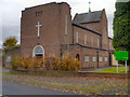
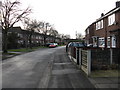
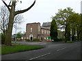
St Aidan's Catholic Church, Northern Moor
St Aidan’s Catholic Church in Northern Moor was officially opened and blessed in October 1955. In 2006, St Aidan’s Church became a Mass Centre and part of the church was transformed into a community space (St Aidan's Centre), which is home to the Catholic Children’s Society in the area.
http://wythcc.co.uk/home/st-hildas-a-st-aidans.html St Hilda & St Aidan’s Parish website
Image: © David Dixon
Taken: 13 Nov 2012
0.24 miles
10
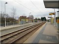
Northern Moor tram stop
On the line to the airport.
Image: © Gerald England
Taken: 11 Mar 2017
0.24 miles