IMAGES TAKEN NEAR TO
Rookwood Avenue, MANCHESTER, M23 0GJ
Introduction
This page details the photographs taken nearby to Rookwood Avenue, M23 0GJ by members of the Geograph project.
The Geograph project started in 2005 with the aim of publishing, organising and preserving representative images for every square kilometre of Great Britain, Ireland and the Isle of Man.

There are currently over 7.5m images from over14,400 individuals and you can help contribute to the project by visiting https://www.geograph.org.uk
Image Map
Images are licensed for reuse under creativecommons.org/licenses/by-sa/2.0
Notes
- Clicking on the map will re-center to the selected point.
- The higher the marker number, the further away the image location is from the centre of the postcode.
Image Listing (29 Images Found)
Images are licensed for reuse under creativecommons.org/licenses/by-sa/2.0
Image
Details
Distance
1
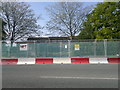
Metrolink works, Baguley
Although not along the exact route of the forthcoming "Airport line" of Greater Manchester's Metrolink network, MPT have cordoned-off this adjacent area of the A560 Altrincham Road in Baguley, Manchester in order to perform some form of works here. Behind, just to the left is a bus stop in the outdated GMPTE livery.
Image: © Steven Haslington
Taken: 21 May 2012
0.05 miles
2
Metrolink Airport Line, Moor Road
To the south of Lawnhurst Avenue, the Metrolink line moves off-road to an alignment using a strip of land on the western side of Moor Road. This land was previously part of Manchester Health Academy (and formerly Brookway High School) Grounds.
Image: © David Dixon
Taken: 3 Nov 2014
0.06 miles
3
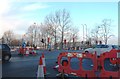
Roadworks for the Metrolink - Baguley
Image: © Anthony Parkes
Taken: 3 Jan 2014
0.07 miles
4
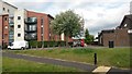
Modern apartments in Pocklington Drive
Image: © David Martin
Taken: 17 Jul 2015
0.09 miles
5
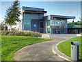
Manchester Health Academy, Wythenshawe
Manchester Health Academy http://www.manchesterhealthacademy.org.uk/ is a mixed-sex secondary school in Wythenshawe, which opened in September 2009 replacing the former Brookway High School & Sports College.
Image: © David Dixon
Taken: 3 Nov 2014
0.09 miles
6
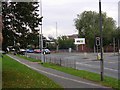
Southmoor Road
Looking in a southerly direction on Southmoor Road, Baguley. The base for the NTL cable TV company in the Manchester area. SJ80528930
Image: © Keith Williamson
Taken: 18 Oct 2005
0.10 miles
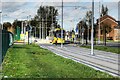
7
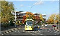
Tram at Southmoor Road
The line runs for a short distance in the street through the junction with Altrincham Road where there was insufficient space to retain separated tracks.
Image: © Alan Murray-Rust
Taken: 26 Oct 2015
0.10 miles
9
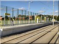
Metrolink Manchester Airport Line, Moor Road Stop
Moor Road Metrolink stop is on a strip of land on the western side of Moor Road. The land was previously a part of Manchester Health Academy and formerly Brookway High School Grounds. The new tram stop is just to the north of the entrance to the Academy. The stop has two facing platforms for inbound (towards Manchester) and outbound (towards Manchester Airport) trams. There is a track-level pedestrian crossing at each end.
Image: © David Dixon
Taken: 3 Nov 2014
0.10 miles
10
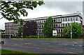
Offices, Southmoor Road, Manchester
Post-war, possibly counting as part of the Southmoor Industrial Estate.
Since pulled down and replaced by a Lidl supermarket.
Image: © Stephen Richards
Taken: 26 May 2016
0.11 miles