IMAGES TAKEN NEAR TO
Milburn Avenue, MANCHESTER, M23 0FB
Introduction
This page details the photographs taken nearby to Milburn Avenue, M23 0FB by members of the Geograph project.
The Geograph project started in 2005 with the aim of publishing, organising and preserving representative images for every square kilometre of Great Britain, Ireland and the Isle of Man.

There are currently over 7.5m images from over14,400 individuals and you can help contribute to the project by visiting https://www.geograph.org.uk
Image Map (Loading...)


Getting Data...Please wait
Leaflet Map data © OpenStreetMap
Images are licensed for reuse under creativecommons.org/licenses/by-sa/2.0
Notes
- Clicking on the map will re-center to the selected point.
- The higher the marker number, the further away the image location is from the centre of the postcode.
Image Listing (7 Images Found)
Images are licensed for reuse under creativecommons.org/licenses/by-sa/2.0
Image
Details
Distance
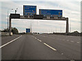
2
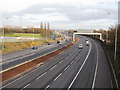
M60 after widening
Finally a motorway fit for purpose, albeit only on the short section near Sale and Northenden originally designated M63.
Image: © Peter Whatley
Taken: 20 Jan 2009
0.10 miles