IMAGES TAKEN NEAR TO
Sale Road, MANCHESTER, M23 0BL
Introduction
This page details the photographs taken nearby to Sale Road, M23 0BL by members of the Geograph project.
The Geograph project started in 2005 with the aim of publishing, organising and preserving representative images for every square kilometre of Great Britain, Ireland and the Isle of Man.

There are currently over 7.5m images from over14,400 individuals and you can help contribute to the project by visiting https://www.geograph.org.uk
Image Map
Images are licensed for reuse under creativecommons.org/licenses/by-sa/2.0
Notes
- Clicking on the map will re-center to the selected point.
- The higher the marker number, the further away the image location is from the centre of the postcode.
Image Listing (10 Images Found)
Images are licensed for reuse under creativecommons.org/licenses/by-sa/2.0
Image
Details
Distance
1
Sale Road, Northenden
Looking in a southeasterly direction from SJ81989026.
Image: © Keith Williamson
Taken: 8 Sep 2005
0.05 miles
2
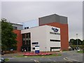
Seat of Learning
City College Manchester, Northenden Campus. (After the amalgamation of City College and MANCAT [Manchester College of Arts and Technology] in late 2008 the combined establishment is now known as The Manchester College).
Image: © Keith Williamson
Taken: 8 Sep 2005
0.11 miles
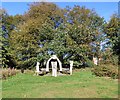
3
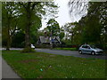
North Lodge, Wythenshawe Park
On the northern periphery of the park, on Wythenshawe Road, and dated 1878.
Image: © Eirian Evans
Taken: 23 Apr 2009
0.14 miles
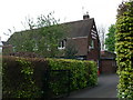
4
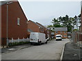
The Pines
A new housing development off Wythenshawe Road.
Image: © Eirian Evans
Taken: 23 Apr 2009
0.16 miles
5
Cyclepath on the boundary of Wythenshawe Park
About to cross the entrance to the park from North Lodge hence the stone blocks to calm the cyclist
Image: © Kevin Waterhouse
Taken: 2 May 2023
0.16 miles
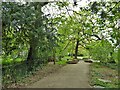
6
Carved seating
On the north side of Wythenshawe Park Image
Image: © Gerald England
Taken: 27 Sep 2018
0.22 miles
7
Quaker Meeting House, Northern Moor
Situated near the Princess Parkway intersection.
Image: © Eirian Evans
Taken: 23 Apr 2009
0.22 miles
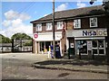
9
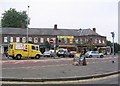
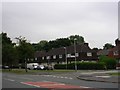
Shops
These shops are on Sale Road near the junction with Carloon Road. The picture was taken from SJ816905 looking south.
Image: © Dave Smethurst
Taken: 5 Sep 2005
0.24 miles
10
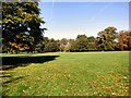
Wythenshawe Park
The park was originally the land belonging to the Tatton family who were established at Wythenshawe Hall. In 1926 the hall and parkland was bought by Lord and Lady Simon and given to Manchester City Council to be kept forever as an open space for the people of Manchester https://secure.manchester.gov.uk/info/200073/parks_playgrounds_and_open_spaces/2242/wythenshawe_park/5
Image: © Gerald England
Taken: 27 Sep 2018
0.25 miles