IMAGES TAKEN NEAR TO
Woodhouse Lane, MANCHESTER, M22 9TH
Introduction
This page details the photographs taken nearby to Woodhouse Lane, M22 9TH by members of the Geograph project.
The Geograph project started in 2005 with the aim of publishing, organising and preserving representative images for every square kilometre of Great Britain, Ireland and the Isle of Man.

There are currently over 7.5m images from over14,400 individuals and you can help contribute to the project by visiting https://www.geograph.org.uk
Image Map
Images are licensed for reuse under creativecommons.org/licenses/by-sa/2.0
Notes
- Clicking on the map will re-center to the selected point.
- The higher the marker number, the further away the image location is from the centre of the postcode.
Image Listing (20 Images Found)
Images are licensed for reuse under creativecommons.org/licenses/by-sa/2.0
Image
Details
Distance
2
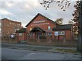
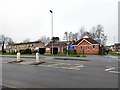
Brownwood Hall, Wythenshawe
Gospel hall on Woodhouse Lane
Image: © David Dixon
Taken: 2 Nov 2012
0.11 miles
3
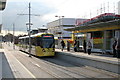
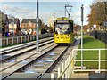
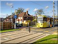
Wythenshawe Town Centre Metrolink station
On only the second day of services on Metrolink's Airport line, car 3070 approaches the northbound platform at Wythenshawe Town Centre station
Image: © Dr Neil Clifton
Taken: 4 Nov 2014
0.16 miles
4
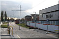
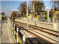
Wythenshawe Town Centre: Metrolink station
Looking south along the tramline towards the Airport. At present, there is a 12-minute off peak service between the Airport and Cornbrook. Only when the second city crossing has been completed, will trams run through into the heart of Manchester. This will be in 2016 if plans go well.
Image: © Dr Neil Clifton
Taken: 4 Nov 2014
0.16 miles
5
Wythenshawe - Woodend Road
A recreation ground lies beyond the end of the tarmac.
Image: © Peter Whatley
Taken: 23 Jan 2009
0.18 miles
6
Housing on Northcote Avenue
Viewed from Crossacres tram stop.
Image: © Gerald England
Taken: 27 Jun 2015
0.19 miles
7
Metrolink Airport Line Approaching Crossacres
Between Benchill and Crossacres, the Metrolink tram line follows a reserved route along the southern side of Brownley Road. Here, Metrolink Bombardier M5000 tram number 3079 approaches the outbound platform of the Crossacres tram stop.
Image: © David Dixon
Taken: 3 Nov 2014
0.20 miles
9
Metrolink Airport Line, Brownley Road
Between Benchill and Crossacres, the Metrolink line is along the southern side of Brownley Road. Here, Bombardier M5000 tram 3086 crosses the box junction at the end of Woodend Road.
Image: © David Dixon
Taken: 3 Nov 2014
0.20 miles
10
Metrolink Manchester Airport Line, Crossacres
Crossacres Metrolink stop is on the southern side of Brownley Road. It has two facing platforms for inbound (towards Manchester) and outbound (towards Manchester Airport) trams. There is a track-level pedestrian crossing at each end.
Image: © David Dixon
Taken: 3 Nov 2014
0.21 miles